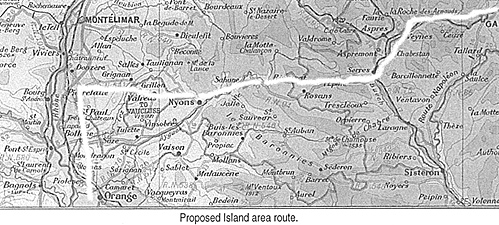
Polybios never mentions this river, but it figures prominently in Livius's account as a difficult stream to cross, with shifting pools and quick-sand like conditions. While not as difficult to cross as the final descent into Italy, it is sufficiently troublesome that it occupies a place in the narrative. After crossing, Livius notes the relatively open country. After heading up the Rhone as far about present-day Donzere, Hannibal turns east towards the Alps, skirting the Vocontii and Tricorii tribal areas and ultimately reaching the foot of the pass somewhere near present day Remuzzat.
The Donzere area is a natural narrowing of the valley--the present day spot has a dam built on the Rhone. Further up would start to encroach on the Allobroges' main area. This is a good spot, especially before reaching the narrows, to turn right so to speak, skirt the northern fringes of Vocontii territory, and head towards the Alps. This is also where the Lockwood proposed route deviates from the others.
Consider Hannibal's dilemma
The weather is starting to turn colder, so for every day of delay, the passes are threatening to be snowed in. The Roman army has not followed up the Rhone valley, so there's no chance of being caught in a battle. Where the Romans went after being evaded at the Rhone crossing is unknown. They either stayed near Massilia to await the return of an unsuccessful crossing, (where else would the army go?), headed to Spain (into those same Gallic tribes that cost casualties), or headed back to Italy (in anticipation of a successful crossing the Alps). That latter option cannot be ignored, and a Roman army blocking the Carthaginian descent on the plains of Italy at the end of an Alpine pass would undo the whole reason for the campaign in the Alps.
Hannibal's thinking would now be based on the lapse of time and the lateness of the season. The army was heading towards the Alps, not further into barbarian Gaul.
It took enough casualties just getting to the Rhone. Hannibal knew the morale of his vets, and being a seasoned campaigner had to realize that they couldn't take too many more losses and still maintain a viable army upon emergence into Italy.
This is not 10 days' worth of marching along the Rhone. It's two-thirds of the way between the Aygues and Drome Rivers, so there's no real following of a river at this point, especially along river banks, if the army cuts cross country and head to the Alps. It's a stretch to say the route follows either of these major rivers. And yet, somewhere between the Rhone and the Alps lies Livius's Druentia "alpine stream," which is not mentioned by Polybios.
At this point, Livius takes precedence, precisely because of the detail about the "Druentia" crossing--it's the sort of anecdote Livius lived for. It may be a bit melodramatic to describe quicksand-like sinkholes and so on, but in one of Livius's sources, it takes on an important role--much the way losses occurred in landslides further along in the narrative. That the incident may have been exaggerated is open to speculation, and indeed, probably is a taller tale with the passing of years, but that there was a rain-swollen stream or minor river to cross before reaching the place of the ascent of the Alps remains in the struggle to reach the Alps.
The present day Lez River cuts through the area between the Aygues and Drome Rivers and lies directly on the path to the Alps. It also eventually leads into the "delta" area of The Island, and open country abounds on the eastern shore before reaching the Alps. From the mountains, the Lez runs SSW emptying into the Rhone about 5km north of where the Aygues River empties into the Rhone. Polybios does not mention the incident, perhaps from insignificance to the march as a whole, or perhaps the number of soldiers lost was minimal compared to the dangers that lay ahead.
But it tallies with Livius and makes sense if Livius is integrating several sources. It is also possible that this marked the extent of the Triscatini tribal area, as this right turn is about where St. Paul Trois Chateau sits, which a few of the historians contend is of a later diocese structure of the Triscatini tribal area. Whether a later diocese boundary conforms to an earlier tribal area is a topic for another time. The modern French departmental boundary lies there too, running generally eastward towards the Baronnies Mountains.
In any case, I believe Hannibal turns right just south of modern day Donzere, around Pirrelatte, and heads eastwards towards the Alps.
Hannibal Crosses the Alps A Route Examined and a Proposed Alternate Route
-
Introduction
The Sources
Hannibal's March: Polybios and Livy
Polybios vs. Livy: Debate Over Details
A New Route Proposed: Begin at the End
A New Route Proposed: Start at the Beginning
A New Route Proposed: Where is the Druentia?
A New Route Proposed: The Pass in the Alps
Aftermath, Conclusion, and Bibliography
Back to Strategikon Vol. 2 No. 1 Table of Contents
Back to Strategikon List of Issues
Back to MagWeb Master Magazine List
© Copyright 2002 by NMPI
This article appears in MagWeb.com (Magazine Web) on the Internet World Wide Web. Other articles from military history and related magazines are available at http://www.magweb.com