
Top to Bottom
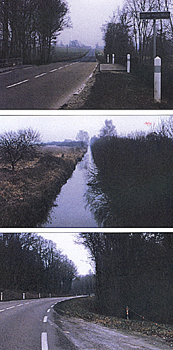
(top)The bridge over the Petit-Morin at St. Prix (at left). The Napoleonic period bridge and road were much narrower. The wood in which the Russian Jaegers attempted to stop Ricard's troops can be seen in the background up the road. The banks on both sides of the bridge are swampy.
(middle)The Petit-Morin. Thirty feet wide, six feet deep, and six feet of mud. Very swampy banks make crossing it impossible except at the few bridges.
(bottom)Defile at St. Prix. Very dense woods, easy to defend--the Napoleonic road was much narrower than the modern highway.
Top to Bottom
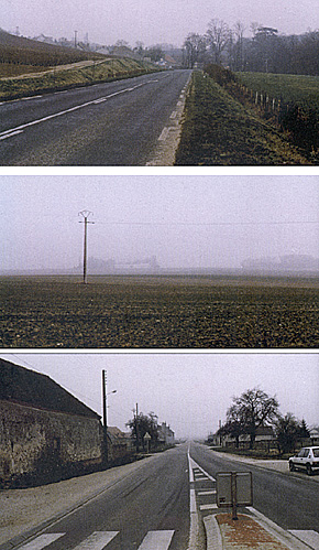
(top) View of the entrance to the town of baye as seen from the south. Baye is in the Champagne region--not much changed from 1814.
(middle) The flat open plateau between the Audecy farm and the Bannay wood where the Russian troops were deployed before being forced to retreat towards Champaubert. One can imagine the difficulty of the Russian retreat in square while under attack by French cavalry.
(bottom) View from Champaubert looking down the road to Etoges and Chalons where Poltoratzki deployed his nine guns. Champaubert has not changed much--these are the same buildings as existed in 1814.
More Champaubert Part II
-
Battle of Champaubert Introduction
French Accounts of Battle of Champaubert
Russian Accounts of Battle of Champaubert
Battle of Champaubert Order of Battle
Champaubert Battlefield Photographs
Large Map 1 (slow: 64K)
Large Map 2 (slow: 152K)
Back to Empire, Eagles, & Lions Table of Contents Vol. 2 No. 8
Back to EEL List of Issues
Back to MagWeb Master Magazine List
© Copyright 1994 by Emperor's Press
This article appears in MagWeb (Magazine Web) on the Internet World Wide Web.
Other military history articles and gaming articles are available at http://www.magweb.com