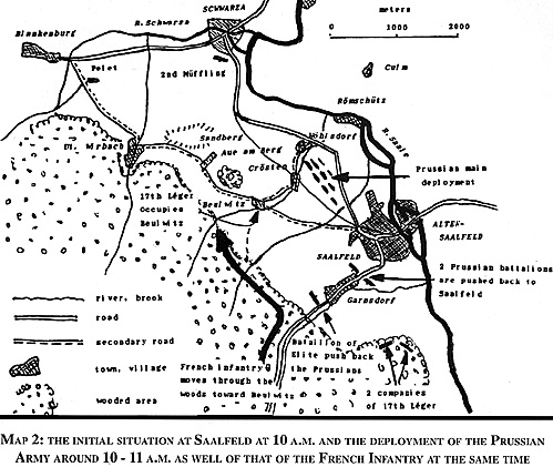
Marshal Lannes, at the head of his infantry, halts on the hill commanding Garnsdorf. This is what he sees: (See Map 2)
At a distance of about two miles is the Saale valley. On the river, Saalfeld, a big town with a circumference of about 2 miles, 300 feet below the level of the woods. Garnsdorf is half way down the slope. More to the north is the small valley of the Siegenbach, then another, that of the Beulwitz brook and the towns of Beulwitz, Crosten and Wolsdorf. Further to the north, the ground rises and forms a spur which commands the bend of the Schwarza and its confluence with the Saale. Highest point of this rise is the Sandberg. The whole countryside is absolutely without cover.
The Marshal's observation is completed by studying the openly displayed enemy army. At the foot of the slopes, on three regularly and correctly drawn lines, appears a force that Marshal Lannes read at 6,000 7,000 men. It is the division of Prince Louis of Prussia. Saalfeld is occupied by the enemy. A few enemy squadrons are seen maneuvering up-river above the town in the direction of the gap of the Saale.
The Prussian Division has its back to the Saale. In case of defeat, it can only retire over the bridge of Saalfeld or over that of Schwarza. It is easy to measure its force. It can not be reinforced for a long time. Lannes will therefore attack, according to the spirit of the orders he has received.
Map 2
MAP 2: THE INITIAL SITUATION AT SAALFELD AT 10 A.M. AND THE DEPLOYMENT OF THE PRUSSIAN ARMY AROUND 10-11 A.M. AS WELL OF THAT OF THE FRENCH INFANTRY AT THE SAME TIME.

More 1806 Battle of Saalfeld
-
Introduction
I: Grand Army and Lannes' Movement Prior to Battle
II: Initial Situation at Saalfeld
III: Events and Intents from the Prussian Side
IV: Lannes' Initial Disposition and Deployment
V: Preliminary Action on Prussian Side
VI: Prussian Attack
VII: Lannes' Attack
VIII: Combats Around Garnsdorf, Saalfeld, and the Pursuit
IX: Conclusions
X: Further Conclusions
XI: The Battlefield Today
Back to Empire, Eagles, & Lions Table of Contents Vol. 2 No. 6
Back to EEL List of Issues
Back to MagWeb Master Magazine List
© Copyright 1994 by Emperor's Headquarters
This article appears in MagWeb (Magazine Web) on the Internet World Wide Web.
Other military history articles and gaming articles are available at http://www.magweb.com
