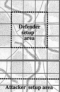
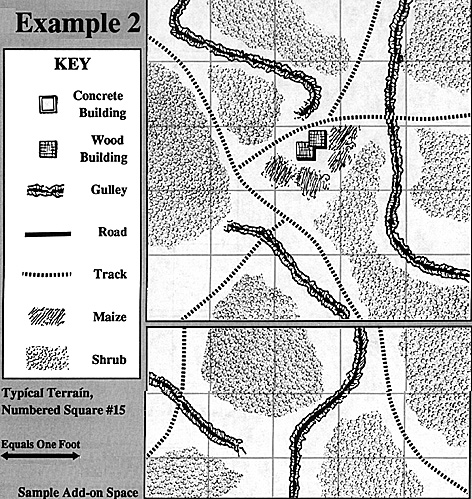
 >The terrain for each point should be drawn up in advance, if possible. I suggest that you make each square 5' square and use the following suggested guidelines. When starting a battle, add an additional section 2 1/2' x 5' along the board edge that a force is entering.
If forces are entering from two edges, add a separate 2 1/2' x 5' section on each edge as needed.
Defenders are restricted to setting up within the central square, but not within 1' of the edge of the center square. The attackers can set up with 1' of the edge of the board that they will enter from. This gives a clear space of 30" between the attackers and defenders at the start of the battle.
Numbered or Lettered Square:
If located on a track only, on a ID6 roll of a 5 or 6, a hamlet exists in this square. Roll 1D6 again and divide it by 2, rounding down. The resulting number is the number of 2" by 2" wooden building sections that make up the hamlet. For each hamlet square, two maize (corn) fields should be located in the area, The fields can range in size from 2" by 4" up to 4" by 8", and are considered as cover for personnel stands on foot, with a visibility of 4" within the field. Vehicles are not affected by fields.
Each square should have 1D6 worth of gullies running through the area. Gullies will be considered as steep-sided, with a limited number of crossing points. Hills should be scarce, with any existing being the location of any hamlet. Tracks and roads should be placed, depending upon the number and location of those connecting that point.
Most of the remaining area should be considered as shrub, with some open sections. Shrub is considered as heath for movement and line of sight.
If the lettered square is located on a Fair Weather road then a hamlet will exist there. Roll 1D6 for the number of wooden building sections present. If a 5 or 6 is rolled, set up two villages instead of a single large one in this square.
Named Square:
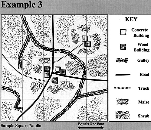
(With the exception of Ngiva, Xangango, and Ondangwa.) Roll 1D 6, and add 3. The resulting number is the total number of building squares found in this square. A modified die roll of 7, 8, or 9 indicates that one building square is concrete.
The town should consist of three to five squares, including the concrete one, and should be located near the center of the square, with all of the roads and tracks entering the square running to it. The remain building squares should be used to form one or two smaller hamlets in the area. For each wooden building square, two maize (corn) fields should be located in the area, using the same rules as above.
Again, each square should have 1D6 worth of gullies running through the area. Gullies will be considered as steep-sided, with a limited number of crossing points. Most of the remaining area should be considered as shrub, with some open sections. Shrub is considered as heath for movement and line of sight.
Ngiva, Xangango, and Ondangwa:
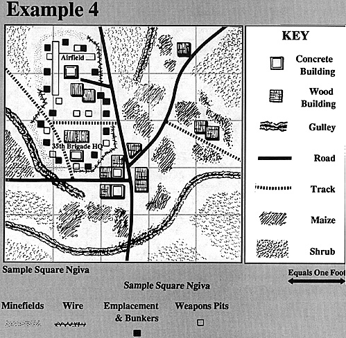
Roll 2D6, and add 1. The resulting number is the total number of building squares found in this square. A modified die roll of 7, 8, or 9 indicates that one building square is concrete. A result of 10 or 11 indicates two squares are concrete, while 12 or higher indicates three squares are concrete.
The town should consist of four to seven squares, including all of the concrete ones, and should be located near the center of the square, with all of the roads and tracks entering the square running to it. The remaining building squares should be used to form one or two smaller hamlets in the area. For each wooden building square, two maize (corn) fields should be located in the area, using the same rules as above.
In addition, an airfield area needs to be laid out. The airfield needs two runways 2" by 15" at an angle to one another, and one 2" by 2" concrete building, as well as two 2" by 2" wooden buildings.
Base Camps, Headquarters, and Barracks:
Areas where Angolan and SWAPO troops are based will have abase camp added to the square. The camp will include three wooded building squares (in the case of the Front or Brigade Headquarters, substitute one concrete square for one wooden one). Note that this is not one base camp per unit, but one base camp for all units present. All fortifications should be placed in defense of the base camp.
Again, each square should have 1D6 worth of gullies running through the area. Gullies will be considered as steep-sided, with a limited number of crossing points. Most of the remaining area should be considered as shrub, with some open sections. Shrub is considered as heath for movement and line of sight.
(The example of Ngiva shown here should have the garrison and city shifted one foot to the lower right hand comer to allow one foot between such facilities and the edge of the board.)


More Externals Mini Campaign Game
- Part I, II, III
Part IV, V, VI, VII
Appendix 1: South African Forces
Appendix 2: Angolan Forces
Appendix 3: Terrain
Campaign Map
More Externals 1980-1989: SW Africa and Angola
- Introduction: 1915-1979
SADF: South African Defense Forces in South West Africa
SWATF: South West Africa Territorial Forces
Koevoet: Operation Crowbar
SWAPO: South West Africa People's Organization
FAPLA: People's Armed Forces for the Liberation of Angola
Cuban Forces in Angola
UNITA: National Union for the Total Liberation of Angola
South Africa Specs: Combined Arms Charts
Back to Table of Contents -- Command Post Quarterly #2
To Command Post Quarterly List of Issues
To MagWeb Master Magazine List
© Copyright 1993 by Greg Novak.
This article appears in MagWeb (Magazine Web) on the Internet World Wide Web.
Other military history articles and gaming articles are available at http://www.magweb.com
