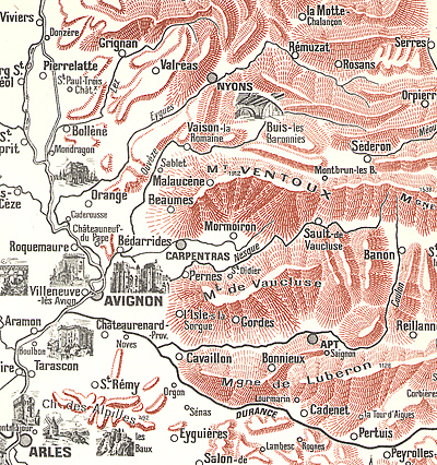
 If you can't pinpoint the crossing of the Rhone, then there is little chance of pinning down everything else that comes after the crossing.
Map from: Provence by Marcel Brion.
If Hannibal averages about 14km per day and he crossed the Rhone "four days" march upstream from the sea where the river is a "single stream," the crossing point should be about 56km up the Rhone River. Lo and behold, at 60km upriver, the Rhone is a wide single stream at Fourques, just above the city of Arles. Bradford picks Fourques as the crossing point, noting it is almost dead on 1600 stades from the Ebro River. De Beer also picks Fourques, as does Prevas, whose 1998 book follows de Beers' 1955 book so closely, it could almost be a clone. Dupuy also says Fourques.
Lazenby votes for just north of Fourques because Scipio and the Romans marched to the spot in three days without his heavy baggage (i.e light forces). He notes the common crossing place is now spanned by a modern bridge from Beaucaire to Tarascon, which is 63 km from the mouth of the western branch of the Rhone. If the crossing is at Beaucaire, then Hanno crossed 200 stadi (35.5 km) at Avignon.
Prevas notes that other places he considered include Tarascon (20km north of Fourques) or Roquemaure (between Avignon and Orange, about 40km north of Fourques)--but both of these are too distant. In any case, he picks Fourques.
Now, Dodge posits Hannibal marched cross country, picking a place now near the town of Roquemaure, just above Avignon, as the crossing point. He claims Rochemaure is just a little over 1600 stades from Emporiae. Roquemaure is about two days marching north of Fourques, or about 100km from the sea, although Dodge makes a point of saying the ancient seashore was likely further inland than today. Gibbon and Napoleon also picks Roquemaure as the crossing point.
Dorey and Dudley place the crossing north of Orange, above the confluence of the Rhone and Aygues Rivers, "a point far enough away to escape interference or observation by Rome's allies in Marseille (Massilia)" (page 39). He claims four days march is 50 miles, or 83km from the sea.
Bath suggests 35 miles, or 60km, is a four day march from the sea, points to de Beer (Fourques) and Lazenby (Beaucaire), and then says "which of these is correct does not seem to me to be of great importance; they are only 10 miles apart and neither has any more tactical or strategic significance than the other." (page 44) Bath opines that de Beer's work "is the definitive one."
Caven sides with Lazenby with a crossing at Beaucaire.
Connolly contends Tarascon-Beaucaire is the crossing place, as it is smack on the Via Domitia road, which he claims the Romans paved over the old Way of Hercules, and roughly 1600 stades from Emporiae. He discounts a crossing at Fourques (Arles) because the area was too flooded and any divergence closer to the Rhone Delta (especially at the town Aigues Mortes as nominated by de Beer) would have been mentioned.
Hannibal Crosses the Alps A Route Examined and a Proposed Alternate Route
- Introduction
Survey of Classical Sources
Hannibal's March According to the Histories of Polybius and Livy
Polybius vs. Livy: Debate over Hannibal's March
Modern Historians: Route Acceptance and Rejection
Modern Historians: Rhone Crossing
Modern Historians: The Island
Modern Historians: From the Island to The Ascent of the Alps
Modern Historians: Ascent to the Alps to the Pass
Polybius vs. Livy: Short Bios
Hannibal's Line of March Considerations: Proposing a Route
Hannibal's March: A Proposed Alternate Route
Conclusion and Bibliography
Back to War Lore: The List
Back to Master Magazine List
© Copyright 2002 by Russ Lockwood.
This article appears in MagWeb (Magazine Web) on the Internet World Wide Web.
Other military history articles and gaming articles are available at http://www.magweb.com