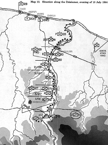
 Map 10 shows the disposition of U.S. forces along and across the Driniumor River about two hours before the Japanese attack. The headquarters map and its unit symbols were operational tools. They represented battlefield reality, the commander's operational deployment, and the enemy situation. They were ready reference aids for the commander and his staff. The artificial structure of battle necessarily imposed by higher
headquarters could not accurately represent every event at the tactical unit level. The vast increase in human activity at the lower links in the chain of command precluded that. From the idealized solitary figure of the commander pondering his next order to the range of complex preparations of a rifle squad before patrol-and the squad was only a tiny fraction of a battalion-generalizations based on individual unit reports could place a
patina of order on the chaos of battle. For instance, 6th Army Headquarters' knowledge of the location of its subordinate units was fairly accurate. The 32d Division, however, probably had a better grasp of the friendly and enemy situation near Aitape.
Line units, like the 112th Cavalry, understood better than those two higher echelons the deadliness of the Japanese infantryman. Individual cavalrymen saw, heard, smelled, or fought their enemy. They were, conversely, almost totally ignorant of how 6th Army had structured the cavalrymen's fight. If order and precision were keynotes of command at the top, confusion and uncertainty over the larger picture were hallmarks at the bottom. To be confused was normal, and uncertainty bred the caution needed to stay alive.
Japan's 18th Army confronted similar circumstances. When General Adachi scanned a situation map, his reactions were probably quite similar to General Krueger's. Adachi knew that Japanese patrols had worked their way across the Driniumor and had observed, heard, smelled, and fought their American foes at close range. Along or near the Driniumor, small groups of armed men moved cautiously through a reeking jungle whose mangrove swamps and twisted roots made even walking an exhausting business. Small fighting patrols from both armies groped blindly in the primeval jungle for their enemies.
When they found each other, higher headquarters could add or subtract another map symbol. Such was the grim reality behind the 112th Cavalry's symbol on the Aitape mapboard. That symbol, a snapshot of the present, said precious little about the soldiers who filled 112th's ranks.
Chapter 4: US 112th Cavalry's Deployment to the Driniumor River
- Chapter 4: Situation Overview
Chapter 4: 112th Cavalry Regimental Combat Team
Chapter 4: To the Drinuimor
Back to Table of Contents -- Leavenworth Papers # 9
Back to Leavenworth Papers List of Issues
Back to MagWeb Master Magazine List
© Copyright 2005 by Coalition Web, Inc.
This article appears in MagWeb.com (Magazine Web) on the Internet World Wide Web. Other articles from military history and related magazines are available at http://www.magweb.com