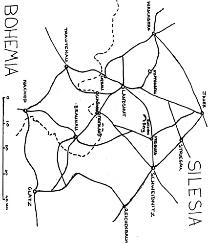
The three hard-fought actions at the otherwise obscure Silesian town of Landshut allow us to glimpse the nature of low-level tactics with some clarity. What makes them particularly interesting is that all three took place on the same terrain with the same basic objective but involving widely varying forces which allows us to assess how different commanders tackled similar tasks.
In each case, both sides sought to secure the town which gave access to several important routes across the mountains along the Bohemian-Silesian border. In the first instance, the Prussians scored a minor victory, with the roles reversed on the second encounter and the final action ending in complete Prussian defeat. As this last engagement is somewhat better known and involved far more troops, it will receive less coverage here in order to concentrate on the first two where the opposing forces were more evenly balanced and the conditions more alike.
The Terrain and Its Significance
Landshut's chief significance derived from its situation on the main road from Trautenau in northeastern Bohemia to Schweidnitz in northwestern Silesia. This road crossed the frontier at Liebau and reached the town by crossing the long, straggling village of Reich-Hennersdorf. Another, secondary road crossed the frontier at Schonberg to the southeast and ran along the Zieder stream to arrive at the eastern side of Landshut. The town itself lay in the valley of the Bober river which flowed out of the Bohemian mountains and then turned north- west to join the river Oder at Crossen. The main road turned northeast and ran past the high Zeisken Berg hill through the town of Freiburg and on to the important fortress and magazine at Schweidnitz.
Whoever held Landshut also had access to roads leading north and west into southern Silesia and Saxony respectively. The town's strategic importance was heightened by its commercial activity as a center for Silesian linen manufacture with several of the firms based there trading as far afield as Spain and providing a valuable source of revenue to the Silesian provincial exchequer.
While Landshut may have been easy to reach, it was not simple to defend. The town itself was small and cramped in a bend in the Bober valley at the confluence with the Zieder. A badly built wall and ditch surrounded the buildings and the church yard which projected to the south east. There were narrow meadows to the east, south and beyond the Bober to the west, but these gave little room to deploy. The surrounding hills were often steep and were so close that they commanded the town and dominated all three actions. The area to the north was dominated by three hills (Castle Hill [Burg Berg], Thiem Berg and Leuschner Berg) stretching in a line southwest to north-east as far as the village of Vogelsdorf.
Another ridge ran almost directly south from this line as far as the Zieder and included three further high points (Mummel Berg, Book Hill [Buch Berg] and Zieder Berg). It continued as a further ridge on the south side of the Zieder curving gently westwards to stop at the Angenelli Berg at the Liebau-Landshut road. This high ridge was broken only by a gap at the eastern end of Reich-Hennersdorf which gave its name to the whole stretch. The Liebau-Landshut road crossed Reich-Hennersdorf and ran over the heights immediately to the south of the town by the Bober.
These included the ominously named Gallows Hill (Galgen Berg) and Justice Hill (Gerichts Berg), as well as Church Hill (Kirch Berg), Rooster Hill (Hahn Berg) and Blue Star Hill (Blaustern Berg). The ground rose again south of Reich-Hennersdorf towards the mountains, beginning with Mill Hill (Mohl Berg) to the west of the road and then higher ground at the defile by Blasdorf.
Open ground was limited to three areas: a narrow plain between the Reich-Hennersdorf ridge and the hills immediately to the south of Landshut; the wider plain of Kloster Grossau in the Zieder valley; and the Liebau plain to the south of the Blasdorf defile. Much of the latter, as well as the ground to the west of the Bober was marshy and dotted with ponds, while a further extension of the Reich-Hennersdof ridge separated the Liebau and Grossau plains.

More Landshut
-
Introduction
First Landshut: 22 May 1745
Second Landshut: 13-14 August 1757
Third Landshut: 23 June 1760
Orders of Battle
Back to Seven Years War Asso. Journal Vol. XI No. 4 Table of Contents
Back to Seven Years War Asso. Journal List of Issues
Back to Master Magazine List
© Copyright 2000 by James J. Mitchell
This article appears in MagWeb (Magazine Web) on the Internet World Wide Web.
Other military history articles and gaming articles are available at http://www.magweb.com