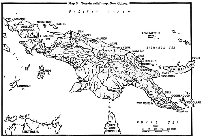
New Guinea is the second largest island in the world and covers more than 885,000 square kilometers. [2] If New Guinea were superimposed over the United States, Milne Bay would be south of Norfolk, Virginia, Lae at Pittsburgh, the major Japanese base of Wewak at Detroit, Biak Island at Minneapolis, and the westward extension of Dutch New Guinea would extend well into the state of South Dakota. A rifleman could hardly be faulted if he thought the reconquest of New Guinea alone would be an endless task. For many it was.
The north coastline is about 2,400 kilometers long, and the island, at its widest point, is 645 kilometers wide, approximately the distance from Washington, D.C., to Cincinnati, Ohio. The island extends from about twelve degrees south latitude to just south of the equator and has a monsoon climate (see map 3).
A major mountain range runs from the eastern end of the island to Geelvink Bay, but a spur just west of the Sepik River leads to a smaller complex of mountains, the Torricelli Range, which runs near and parallel to the north coast from Wewak to the Mamberamo River. The Torricellis rise as high as 1,420 meters, but the mountains are considerably broken with many rough ridges and deep gorges that bar the passage of large military formations. The crest of the range, about twenty-five kilometers south of Aitape, canalized Japanese westward deployment between the foothills and the coast.
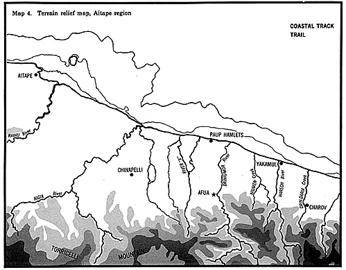
Bordered on the north by the Pacific Ocean, the Aitape area is a coastal plain covered by rain forest with numerous swampy places (see map 4). Streams and rivers running north from the Torricelli Range cut the narrow coastal plain at numerous places. The Driniumor is one of six main rivers in New Guinea, and it flows rapidly through the Torricelli foothills before it enters the plain at Afua, a native village on the river's west bank and the scene of heavy fighting in August 1944. Normally the Driniumor can be waded. It is 1 meter deep with a course of 145 meters and a bed 37 meters wide, but both width and depth vary greatly depending on the amount of rainfall.
Aitape receives nearly 250 centimeters of rain annually. The wet season during the northwest monsoon lasts from December to April. Although there is an appreciable difference in the amount of rainfall from May through November, monthly averages are more than 17.5 centimeters. During July and August (the period of the major fighting along the Driniumor in 1944), torrential tropical downpours are the rule, and quick runoff from the mountains results in rapid stream risings on the plain. Humidity is
naturally high, as is the temperature range of 38 degrees to 20.5 degrees C. Clouds are least likely at the lower elevations in the morning after sunrise.
Fog is not a problem near the coast, but inland it is quite common, especially in valleys and near rivers. In 1944 sunrise was at 0635 on 5 July, sunset at 1833. Comparable figures for 5 August were 0636 and 1835. There was a full moon on 6 July and 4 August, and moonrise varied from 1713 on 5 July to 1924 on 5 August. Aitape is not a particularly pleasant place to live. Deteriorating into a slithery morass capable of engulfing the unwary soldier, it is a worse place to conduct large-scale military operations.

Chapter 1: Ultra and Pacific Strategy
Back to Table of Contents -- Leavenworth Papers # 9
Back to Leavenworth Papers List of Issues
Back to MagWeb Master Magazine List
© Copyright 2005 by Coalition Web, Inc.
This article appears in MagWeb.com (Magazine Web) on the Internet World Wide Web. Other articles from military history and related magazines are available at http://www.magweb.com