SF Off-Map Movement
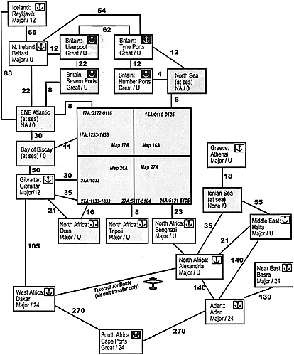
Here is an optional Off-Map Distances Chart for Second Front, which players may use in place of the game's "Off-Map Port Summary". It expands on the Off-Map Port Summary, offering additional choices such as
The off-map movement is particularly applicable when used with the air unit crating, and the Takoradi air route.
Allied Off-Map Ports. The Allied player has off-map ports for various of his holding boxes, as listed on the off-map distance chart.
Each off-map port is displayed on the chart as a port box, which list the port's holding box, port name, port size, and airbase capacity. An off-map port is always functioning and cannot be damaged. The chart also contains sea boxes, which contain no ports, map entry/exit hexes, and naval routes between the boxes. Each route shows the number of naval movement points between points on the chart. For example, the great port of Liverpool in the Britain holding box is 12 naval MPs from Belfast in the Northern Ireland holding box, and is 18 naval MPs from the ENE Atlantic sea box. The ENE Atlantic sea box is 8 hexes from the map entry/exit hexes of 17A:0122-0116.
The Allied player may move his naval groups (and any cargo) on the chart from box to box and between the map and the boxes. A naval group may exit or enter the map at the indicated map entry hexes. Naval groups may not use the Takoradi Air Route.
It may take more than one movement step for a naval group to move between the map and an off-map port. Use status markers or make a note to keep track of the progress of the moving naval group.
Allied Off-Map Air Movement. Each port box is also an airbase, with an airbase capacity. Sea boxes have no airbases. Air units can fly air transfer missions from box to box on the chart and can fly any allowed missions between a box on the chart and the map. Since the distances shown on the chart are calculated for naval movement purposes, use only 75% of the distance for air movement. For example, a distance of 12 on the chart would cost a naval unit 12 MPs but an air unit only 9 MPs. (This of course is not completely accurate in-all cases but works acceptably.)
An air unit may fly from one box to the other by flying an air transfer mission; when arriving at its destination box it immediately becomes inoperative.
Air units may use the Takoradi Air Route to transfer air units between Dakar, West Africa, and Alexandria, North Africa. (The air route was a series of transfer airfields across central Africa that could be used even by shorter-ranged aircraft). Transferring between the Dakar box and the Alexandria box requires an air transfer mission and takes a full turn.
Other ports. To keep things simple and save space, the display shown here omits The Clyde ports (circa Europa map 12A: 1401, near Glasgow) on the west coast and the Firth / Tay ports on the east coast. You can do everything you need to in SF with the port complexes shown; including more just adds more details without enhancing play at all. If you want, you could add to the Britain holding box:
I haven't worked out the distances, but as a rough guide Clyde Ports would be 1/4 or 1/3 the distance of the trip from Liverpool to Tyne ports, Scapa Flow about 1/2 way, and Firth/Tay Ports about 2/3 to 3/4 the way.
You may also notice that the distance to Greece is now longer than on the original SF chart. The new chart calculates the distance via the Ionian Sea. The original chart put the distance at 20 which assumes the Corinth Canal is in use.

More Inside Europa
-
Crating Air Units
Garrisons
Second Front Player Sequence
British Cadres
Second Front Off-Map Movement
Back to Europa Number 59-60 Table of Contents
Back to Europa List of Issues
Back to MagWeb Master Magazine List
© Copyright 1997 by GR/D
This article appears in MagWeb (Magazine Web) on the Internet World Wide Web. Other military history articles and gaming articles are available at http://www.magweb.com