THE MAP
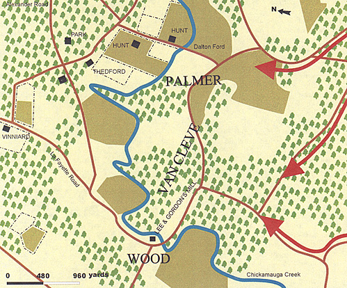
As mentioned previously, I have taken the Union positions to straddle the creek with Van Cleve and Palmer on the east bank. Wood's men may also have been on both sides, though unlikely. Using the scale and a piece of tracing paper, a battlefield can be extrapolated for use on the table. The darker areas on the map are cultivated fields, possibly broken terrain, the red arrows are possible Confederate approach points, all of which could be used at the same time.
TERRAIN
The whole area is fairly flat and, although heavily wooded, is also well cultivated. Several fields are surrounded by fences, but most terrain is open, especially in the southern part of the area. I would suggest giving a battlefield some small folds in the ground, but nothing as grand as hills or ridges. Chickamauga Creek is about waist deep in most places and therefore impassable to wheeled vehicles, except at a recognised bridge or ford. Infantry could wade the creek, but this would slow them down considerably and cause widespread disorder in the ranks.

Lost Victory: Lee and Gordon's Mill 1863
Back to Table of Contents -- Charge! # 6
Back to Charge! List of Issues
Back to MagWeb Master Magazine List
© Copyright 2005 by Scott Mingus.
This article appears in MagWeb.com (Magazine Web) on the Internet World Wide Web.
Other articles from military history and related magazines are available at http://www.magweb.com