Action at Sochocin
24 December 1806
The Situation
by Robert Goetz, USA
| |
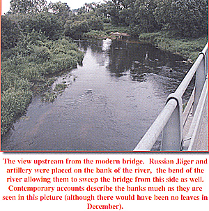
The view upstream from the modern bridge. Russian Jäger and artillery were placed on the bank of the river, the bend of the river allowing them to sweep the bridge from this side as well. Contemporary accounts describe the banks much as they are seen in this picture (although there would have been no leaves in December). On 22 December, Kamenski shifted two battalions under the command of Colonel Iakov Iakovlevich Davydovskii from Borkowo and placed them under Barclay’s command at Sochocin to strengthen the position. The plank bridge, which had been destroyed by the Russians previously, was rebuilt in preparation for Kamenskii’s offensive. For Napoleon, Sochocin was the key to his planned “maneuver sur les derrieres” in which he would turn the Russian right flank. Napoleon ordered the VII Corps of Marshal Pierre Francois Charles Augereau to march from Plonsk to clear the Wkra opposite Kolozab and at Sochocin, seize or restore the bridges and advance on the Russians at Nowemiasto to pressure the Russian right. Seizure of the bridge at Sochocin would allow the French IV Corps of Marshal Jean de Dieu Soult to march rapidly on Ciechanow and then turn and fall on the Russian right and rear. While Napoleon’s plan did not take into consideration the thick mud and abysmal roads that made rapid movement impossible, Sochocin remained central to his plans. Soult’s forces, however, still crossing the Vistula on 22 December, were assigned an impossible task. Sochocin occupies a strategic position at the point where the road from Plonsk to Ciechanow crosses the Wkra. This road reaches the Wkra approximately 200 meters southwest of Sochocin and runs parallel to it along the right bank before crossing the river and entering the town. From Plonsk to Sochocin, about 8 km to the northeast, the road runs generally downhill. From Sochocin to Ciechanow, about 20 km beyond Sochocin, the ground trends generally upward to a point midway between the two towns and then levels off as it approaches Ciechanow.
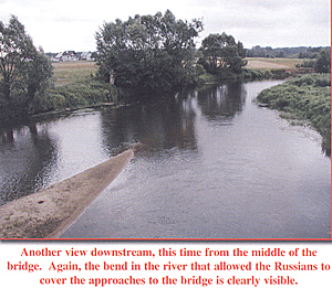
Another view downstream, this time from the middle of the bridge. Again, the bend in the river that allowed the Russians to cover the approaches to the bridge is clearly visible. Davydovskii’s position at Sochocin was a strong one. The bridge at Sochocin crosses the river just above the point where the river turns to the southwest, placing it inside the angle formed by the river. This provided a clear field of fire on the approach to the bridge from the left bank for a considerable distance on either side of the bridge. The absence of any nearby fords secured the position from any turning manoeuvre, and the level ground on both sides provided no advantage for an attacker. Scrub growing along the banks of the river afforded excellent cover for defenders lining the riverbank while woods, at the time apparently extending right up to the riverbank south of the town, provided depth of cover, which the Russians would use to their best advantage. North and south of Sochocin the right bank of the river is quite steep, although on either side at Sochocin it is fairly level. The Wkra is unfordable for at least 9 km above Sochocin, although above that point the river is considerably narrower. Between Sochocin and Kolozab (about 4-5 km downstream) the river is also unfordable. Action at Sochocin 24 December 1806 Back to Table of Contents -- First Empire #69 Back to First Empire List of Issues Back to MagWeb Master Magazine List © Copyright 2003 by First Empire. This article appears in MagWeb (Magazine Web) on the Internet World Wide Web. Other articles from military history and related magazines are available at http://www.magweb.com |
 In the fourth week of December 1806, the bridge at Sochocin played a crucial role in the plans of both the Russian and French commanders. For Field Marshal Mikhail Fedorovich Graf Kamenskii, overall commander of the Russian forces in Poland since 21 December, Sochocin was the point where the right column of his army would cross the Wkra when he launched his offensive to drive the French back across the Vistula. Major General Mikhail Bogdanovich Barclay de Tolly had commanded the Advance Guard on the Russian right at Kolozab and Sochocin since about 5 December.
 Two minor roads east of the Wkra also played a
significant role in the action of 24 December. The river road that follows the left bank of the Wkra for most of its length connected Sochocin with Barclay’s position on the Plonsk-Nowemiasto road opposite Kolozab. A road also travels east from Sochocin for about 6 km before angling southeast for another 4 km to Nowemiasto, passing over rolling terrain, allowing the forces from Sochocin to reunite with the forces from Kolozab at Nowemiasto should they be forced to retreat.
Two minor roads east of the Wkra also played a
significant role in the action of 24 December. The river road that follows the left bank of the Wkra for most of its length connected Sochocin with Barclay’s position on the Plonsk-Nowemiasto road opposite Kolozab. A road also travels east from Sochocin for about 6 km before angling southeast for another 4 km to Nowemiasto, passing over rolling terrain, allowing the forces from Sochocin to reunite with the forces from Kolozab at Nowemiasto should they be forced to retreat.