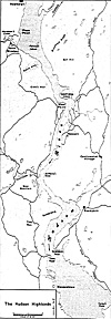
Late in August the New York Convention finally appointed a five-man commission to supervise the fortification of the Hudson Highlands near West Point and Martelaer's Rock. Shortly thereafter, the commissioners engaged Bernard Romans, a Dutch botanist, to be their military engineer. Romans, had few credentials to recommend him for military work. But because there were so few engineers in America, the commissioners had little choice and counted themselves lucky to find anyone with a modicum of training or experience to construct the proposed fortifications.
Jumbo Hudson Highlands Map (slow: 164K)
When Romans arrived in the Highlands, he moved onto Martelaer's Rock and immediately reconnoitered the terrain looking for the best possible sites for gun batteries to cover the river. Concentrating on a grand bastion (named Fort Constitution after the British Constitution) on the southwest end of the island, Romans began to build a poorly sited fort which failed to take best advantage of the range of his guns and the constricted Hudson River channel between the island and West Point*. [*The military importance of terrain is key to the understanding of the value of the West Point area. Failure to use the best available terrain illustrates the Problems associated with non- professional leadership during the Revolutionary War.]
Moreover, Romans inexplicably ignored the recommendations of Tappen and Clinton to fortify the dominating heights of West Point across the river. If the Americans had been required to rely on Romans' position to stop the Royal Navy, a British captain of Nelsonian stripe probably would have been able to run the river gauntlet with ease.
When the commissioners discovered Romans' plans for siting the defensive works, they were furious. Unfortunately for the American cause, Romans and the commissioners then argued bitterly about the development of the island's fortifications, delaying construction even further and endangering the security of the Hudson Highlands. When news of the argument reached the Continental Congress, it decided to arbitrate the dispute by appointing a committee to inspect the fortifications on the island. Arriving in November 1775, the Congressional commissioners did not like what they found. The works were so little advanced and so poorly sited that, in reality, Fort Constitution did not exist as a barrier to the Royal Navy. Also, the. Patriots had not blocked the landward approach from the east. Furthermore, like Clinton and Tappen before them, they saw the ground across the river at West Point dominated Romans' position. Before they left the island, the inspectors concluded that neither the New York commissioners nor Romans could handle the job of fortifying Constitution Island.
The Congressional report naturally concerned the New York Provincial Assembly, so that body appointed its own committee to visit the island to smooth out the differences between Romans and the commissioners. Although the New York committeemen were also unable to improve conditions on the island, they did recommend that the Patriots fortify the ground near Popolopen Creek, about seven miles south of West Point, instead of Constitution Island. The idea of fortifying the area near Popolopen Creek was a good one, if not new. Romans and the commissioners, in one of their rare moments, had agreed that fortifications there would be better than on Constitution Island. Still, the New York inspectors ignored West Point.
As 1775 ended, the Patriots had not progressed very far with their fortifications on Constitution Island. In the next few weeks the Continental Congress ordered the construction on the island stopped and then started again. To further disrupt efforts at fortifying the Highlands, Congress approved building the new fortifications near Popolopen Creek, a project which eventually brought the work on Constitution Island to a standstill.
Since only relatively simple field-type works were required on Constitution- Island, it is hard to believe that the Patriots accomplished so little in the fall of 1775. News from England indicated that they were going to have a stiff fight on their hands as soon as British reinforcements arrived. But even then the historic problems of raising a new army frustrated the colonials: an inadequate command system, lack of money, conflicting priorities, untrained leaders, inexperienced troops, lack of labor, graft, drunkenness, and just plain inefficiency. In 1775, the British could have taken the Highlands easily. In the spring of 1776, new efforts were directed at blocking the river: at Popolopen Creek, south of Constitution Island, the Americans began to build Fort Montgomery -named for the American commander killed in the preceding winter during: the American invasion of Canada.
Shortly thereafter, Washington heard about the poor condition of the fortifications in the Highlands. Gravely concerned he assigned a new officer to command the area; additionally he sent an inspection team under Brigadier General William Alexander, Lord Stirling, to assess the situation for him. Lord Stirling and his assistants did a thorough job. They recommended that works be built at Stony Point and Verplanck's Point and that a new position be built on the south side of Popolopen Creek on the high ground which overlooked Fort Montgomery. At Constitution Island, Stirling's party, like previous ones, saw that West Point dominated the island and recommended that a redoubt be placed on the west bank. Unfortunately, in his summarized report to Washington, Stirling did not mention West Point and the Patriots ignored this critical area again.
More History of West Point
-
Introduction
1775: Constitution Island
1776: Twin Forts of the Popolopen
1777: Defeat in the Highlands
1778: Fortifications of West Point
1779: Stony Point
1780: Treason
1781-83: Yorktown to Peace
1802: US Military Academy
Back to War Lore: The List
Back to Master Magazine List
© Copyright 2001 by Coalition Web, Inc.
This article appears in MagWeb (Magazine Web) on the Internet World Wide Web.
Other military history articles and gaming articles are available at http://www.magweb.com