The Battlefield
I sped down Interstate 76 at a steady 75 miles per hour, the vast expanse of eastern Colorado countryside rolling away to the horizon. Beyond the fence-lined highway, prickly scrub called Russian thistle covered the gnarled landscape of criss-crossing ravines and undulating rises.
Summit Springs battlefield lies about 125 miles northeast from Denver, and while you might call this featureless plain "flat," it was anything but a flat plane. Back in the 19th century, Indian warriors of the American "Wild West" received grudging praise for their ability to melt into such tumbled terrain. A first-hand look serves well to indicate such acclaim, even if it was rocketing down the interstate at speeds far faster than any cavalry patrol or wagon train would travel.
I was actually heading for Beecher Island Battlefield further east and just about on the border of Kansas, but I noted the Summit Springs pockmark on the map roughly two-thirds of the way there and not far out of the way. The weather was a very pleasant mid-60s on a generally sunny day, so I'd welcome the break to stretch my legs and investigate another battlefield.
At around the 80 mile marker, you'll pass Fort Morgan, CO, which started in 1864 as a military fort, but is also the birthplace of bandleader Glenn Miller. There is supposed to be a museum on Main Street, but I cannot say because I passed the exit by, pressing on to the battlefield. I rolled through range country, the scrub having gradually given way to grasslands.
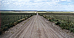
Summit Springs sits between Atwood (exit 115) and Akron, Colorado, just southwest of Stirling, along Highway 63. Don't expect giant tourist information signs. I pulled off I-76 to see a single weathered sign noting a "Historic Site" five miles to the south.
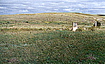
At the end of the five miles, a dirt road headed off to the east, generally bringing you uphill, and devolved into more of a track. At a bend in the road, a windmill slowly pulled water from an underground well. The cattle seemed uninterested in the basin full of water. The road bent around again and ended in a cul-de-sac encircling the land which once was the location of a Cheyenne camp.
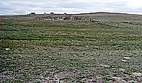
Camp
Large Photo of Camp (slow: 85K)
Chief Tall Bull was among the 52 Indians killed in the battle; 418 horses and mules were captured, and 84 lodges were put to the torch. Fifth Cavalry scout Buffalo Bill Cody later made this last plains Indian battle in Colorado a regular feature of his Wild West show."
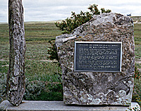
If you look behind the tablet, you'll find a cracked marble tablet with some of the words missing:
"Our Lands are Where Our Dead Lie Buried"
Chief Tall Bull, Heavy Furred Wolf, Pile of Bones, Lone Bear, Black Sun, White Rock, Big Gip, Powder Face, and forty-five Cheyenne and Sioux men, women, and children also died here.
Richard Tall Bull (great grandson of Chief Tall Bull) came to this place on July 11, 1969 and prayed that the Indian nations might live. He pleaded that all men "live in harmony and respect one another."
Large Photo of Inscription (slow: 99K)
Smaller markers, originally erected by the Stirling Lions Club in 1933 and replaced in 1964, note the location of the lodge of Tall Bull as well as where Tall Bull met his demise. Each marker measures approximately 10 inches high by 12 inches wide and sits on a 3-inch-high pedestal. The markers were placed to mark particular locations under the direction of Captain Luther North on June 6, 1929.
And:
Not being a big fan of trespassing, and with a barbed wire fence serving as a deterrent, I passed on the opportunity of walking over for a close-up look at the canyon, but a 300mm telephoto lens on a camera helped take some close-up photos.
Large Photo of Plains (slow: 102K)
Instead, though you had to strain your ears at first, the faint rustle of the breeze skipped across the ground. Somewhere, bugs clicked and chittered in cacaphony. The steady creaking of the windmill floated over the battlefield. And all too soon, so too did my footsteps as I walked back to the car to head for Battle of Beecher's Island battlefield.
 The historical site is flat, with but a couple monuments to record the action of July 11, 1869--no gift shops, no vistors center, no interpretive maps. One tablet, erected by the State Historical Society of Colorado in 1966, offers the following information:
"Fleeing after a series of bloody raids on the Kansas frontier, a band of 450 marauding Cheyenne Dog Soldiers led by Tall Bull (Tatonka Haska) camped here. On the afternoon of July 11, 1869, 300 men of the 5th Cavalry and the Pawnee Scouts under General E.A. Carr made a successful surprise attack on the camp.
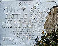
Summit Springs
Battle Ground
Last Indian Engagement
with US Troops in (?) [perhaps "Colorado"?--RL]
Erected by Stirling Lions Club
June 4, 1944
 Another marker, erected August 1970 by "concerned members of both the red and white races in the moon of black cherries," notes the heroism of an unnamed 15-year-old Cheyenne youth:
"In recognition of an unknown fifteen-year-old Cheyenne herdboy who was slain in the conflict at Summit Springs, July 11, 1869. He was killed while stampeding the horses into the Indian village, thus enabling many of his people to escape. Luthor North, army scout, said of the heroic youth: "No braver Man Ever Lived."
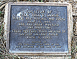 More Markers
Tall Bull's Lodge
where Mrs. Weichel was found
July 11, 1869. She had been wounded
but survived."
of the
Cheyenne Renegade Indians
was shot dead by
Major Frank North
in the canyon 1/4 mile
southeast of this spot
in the battle of Summit Springs
July 11, 1869."
 Canyon
 As I stood looking westward towards Denver, the wind gusted in from the west over the plains. In 1869, the pony wars were in full swing, but on a September day in 1996, silence reigned. But if you stood still for a moment, you'd hear much more than a lack of automobiles or radios or other noise.
Back to List of Battlefields
Back to Travel Master List
Back to MagWeb Master List of Magazines
© Copyright 1998 by Coalition Web, Inc.
This article appears in MagWeb (Magazine Web) on the Internet World Wide Web.
Other military history articles and gaming articles are available at http://www.magweb.com