Fresh from the Summit Springs battlefield, I barreled southward down Highway 63, hung a left at Akron, and headed east on Highway 34 through Yuma and into Wray. Here, I turned south again on Highway 385 and proceeded to try and get lost.
Few roads cut off from 385, and the map showed the road to the battlefield somewhere around 10 miles from Wray. Sure enough, I missed the turnoff. Fortunately, I spied a sign for the battlefield in the rear view mirror, and executed a U-turn. No, it wasn't a power slide worthy of a Hollywood stunt movie, but it set me on the right track, or in this case, a little gray road on the map.
Ample parking is available, for the location is now a campground. Sadly, I arrived on Monday, the day after the anniversary of the battle, and a day after a featured re-enactment of the battle. According to a remaining fellow, these annual re-enactments feature a number of different eras.
Second Monument
One face of the monument notes:
The scouts were surrounded and held on this island for nine days, subsisting on horse and mule meat.
Indians killed, 75; wounded, unknown. Here Roman Nose and Medicine Man fought their last battle.
Another side lists the "uninjured:"
Five gravestones form a half circle around the monument (from east to west):
Beecher's Island Battlefield and Battle Descriptions and Photos
Related
 The terrain leading to the battlefield is quite hilly and cut with ravines and swales--a little wilder and harsher than the land around Summit Springs.
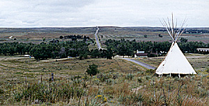 From the north, you'll notice a sign and a small parking lot for Squaw Hill on the east side of the road. A trail leads up a small incline to a path that parallels the road. Here, a small marker atop a concrete pedastal marks the location where the Indian women watched the battle. Further along the trail, a tepee locates a good spot to view the battlefield on the Arikaree River.
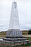 I parked by the obelisk monument (at right, with Roman Nose Ridge in the background), which is the second monument to mark the site. The first one washed away in the flood of 1935. The base is engraved with a variety of information.
Battle of Beecher's Island
Fought Sept 17,18,19 AD 1868 between Col. Geo. A. Forsyth's company of citizen scouts, numbering 51 men, and a large party of Indians comprising northern Cheyennes, Ogallalah, and Brule Sioux and Dog Soldiers commanded by the noted War Chief Roman Nose.
T. Alderinge, M. Burke, J. Donovan, A.J. Eutsler, A. Dupont, J. Hurst, A.T. Grover, G. Green, J. Lyden, M.R. Lane, J. Lane, M.R. Mapes, T. Murphy, H.T. McGrath, C.B. Nichols, G. Oakes, C.C. Piatt, A.G. Puley, W. Reilly, T. Ranahan, C. Smith, J.S. Stilwell, S. Schlesinger, E. Simpson, W. Stewart, I. Thayer, P. Trudeau, C.P. Whitney, W. Wilson, E. Zigler
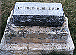 Lewis Farley
Wm. Wilson
Lt. Fred Beecher
Dr. J.H. Mooers
George Culver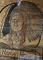
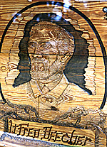 Facing the monument is an information board with a carved wood map of the battle, plus carved wood illustrations of Lt. Fred Beecher and Chief Roman Nose. This information board also contains a bulletin board for local information, as there is a picnic ground and a number of modern buildings adjacent to the battlefield.
Back to List of Battlefields
Back to Travel Master List
Back to MagWeb Master List of Magazines
© Copyright 1998 by Coalition Web, Inc.
This article appears in MagWeb (Magazine Web) on the Internet World Wide Web.
Other military history articles and gaming articles are available at http://www.magweb.com