The Battlefield
 Antietam National Battlefield covers roughly 12 square miles, just slightly to the east of Sharpsburg, MD. Access to the battlefield is relatively quick off of Interstates 81 and 70, and the area remains relatively rural--unlike Gettysburg further north, which has numerous commercial intrusions right up to the park boundary line. Sharpsburg is getting a facelift in 1997, with the main street, sidewalks, and other parts of town renovated to make it more walkable--similar to Fredericksburg.
 The Visitor's Center is easily found off state highway 65 and offers a theater, small museum, bookshop, observation deck, restrooms, and off-street parking. Admission is $2 per adult ($4 for a family) which is good for seven days of admission (according to the ticket at left). Park rangers provide tours and talks, there is a short movie explaining the battle, and you can pick up various pamphlets to help with your walk around the park. Paved roads allow you to drive around the battlefield, and there is an "autoroute" you can follow, but the best way is to park the car in a few locations and then walk around.
Museum
The museum, though small, is worth the visit, especially if you have 15-20 minutes before the next showing of the Antietam movie. Four paintings of various portions of the battle dominate the walls. These were painted by James Hope, a Scotsman turned Captain of the 2nd Vermont infantry regiment. Disabled by illness, this professional artist was assigned mapmaking duties and was an eyewitness to the battle.
The paintings represent:
- Sedgewick's attack towards Dunker Church in the morning.
- French's attack on Bloody Lane (Sunken Road) in late morning.
- Continuing attack towards the Piper Farm (after Bloody Lane).
- Burnside's attack across the Lower Bridge in early afternoon.
The four paintings were on exhibit at his gallery in Watkins Glen, NY. Afte his death in 1892, the paintings were stored, but a flood damaged much of his work. The National Park Service launched a salvage operation to repair them in 1979. There was a fifth painting, but little survived other than a small fragment.
Under Glass
Display cases lining the walls hold various uniform items, including body armor (similar to a cuirassier's plate armor) that saved the life of General Nathanial Wales. Canteens, muskets, swords, pouches, bullets, and other ACW items are on display. A computerized kiosk allows you to search for names of soldiers, although it is helpful to know the unit while looking, as many names are identical.
A drum is on display, with dark brown circumference and stained wood rim, an off white membrane, off white rope lashing it together with tan leather patches. A 6pdr artillery ball is just a little smaller than a softball (or a little larger than a hardball baseball), while a 20pdr Parrot round is a foot-high tube with pointed end of about the same radius.
Bookstore
 A small bookstore is well stocked with Civil War titles--many usually found in larger bookstores, but also a good selection of lesser distributed titles. Two inexpensive items caught my eye:
-
The Battlefield of Antietam ($3.00), a collection of old photographs shows the battlefield at the turn of the century and recounts some tales about the battle and some after it.
Site of the Battle of Antietam Creek or Sharpsburg 17 September 1862 ($1.25), a 3.5- x 2.3-foot map of the battlefield as it was in 1862. Four types of roads (turnpike, secondary road, country road, and farm lane), five types of fences (stone, rail, post and rail, picket, and "undetermined"), five types of flora (orchards, woods, pasture, corn, and stubble), plowed fields, and the creek are marked at a scale of 1cm=100yards. It only lacks contour lines.
General Terrain
 The northern part of the battlefield is relatively flat--although the term "rolling" terrain is more appropriate given the undulating nature of the fields--gradually giving way to steeper terrain as you work your way south. Your line of sight is generally restricted to a couple hundred yards in any direction throughout most of the central and southern parts of the battlefield, and a bit longer view in the northern part. Selected heights, for example, the ridge by Dunker Church, offer a much better view closer to 1000 yards, sometimes longer, in most directions.
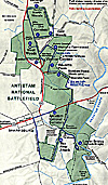
Larger version of park map
Still, especially given the idea that the battlefield was more forested in the mid 1800s, the best way to see and appreciate the battlefield is by foot. Of note, at the time of the battle, 345 acres were forested, including 75 acres of West Woods, 19 acres of North Woods, and 39 acres of East Woods. Today, these are far smaller "woods" and are being reforested with native species, including oak, sycamore, and hickory trees.
One option, and an envious one, is to tour the battlefield on bicycle. Some of the steeper parts in the south, specifically around Burnside's bridge, may give you pause, and heat and traffic in the summer may test your mettle, but you will get a better appreciation of the terrain than traveling by car.
You should budget five to six hours to visit the center, watch the movie, saunter through the museum, drive through most of the battlefield, walk around a bit, and generally see the battlefield. You should plan to take a picnic lunch, as restaurants are in short supply around the battlefield--Sharpsburg has a couple taverns and a bakery, there's the Battleview restaurant a mile or so up the road, and that's about it. A major concentration of fast food places, gas stations, and convenience stores is 10 miles away up State Highway 65 where it meets I-70.
Finally, there is no "relic hunting" within the park, with fines up to $250,000 and 5 years in jail.
For more information: Antietam National Battlefield, PO Box 158, Sharpsburg, MD 21782, (301) 432-5124.
Antietam
This article appears in MagWeb (Magazine Web) on the Internet World Wide Web.
Introduction to Antietam Battlefield
The Campaign
Morning Phase: The Cornfield
Midday Phase: Bloody Lane (Sunken Road)
Afternoon Phase: Burnside's Bridge
Conclusion: Aftermath
Back to List of Battlefields
Back to Travel Master List
Back to MagWeb Master List of Magazines
© Copyright 1997 by Coalition Web, Inc.
Other military history articles and gaming articles are available at http://www.magweb.com