
Malta possessed in its Grand Harbour and other ancillary harbours and anchorages, the finest fleet base in the Mediterranean. It could give secure refuge, watering and fueling facilities to the largest fleets in the world.
The accident of nature that had carved Grand Harbour with its attendant creeks out of Malta's northern coast into a deep water basin that could accommodate the drafts of modern battleships and aircraft carriers, including their attendant deep-laden tankers had made its acquisition important even in the days of wooden ships and sail.
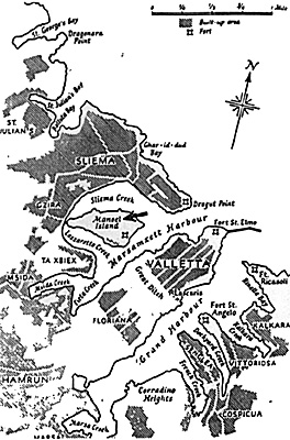
Approached from seaward, there was no more imposing harbour in the Mediterranean than Grand Harbour. On the right stood Fort St. Elmo, a star-shaped bastion built on the site of the fortress that had defied the Turks on 1565 - - hunched heavy shoulders in protection of the grid plan city of Valletta behind it, undulating over the hills of limestone on which it was built. The light shining clear down the mathematical lines of the streets, Valletta's sides were protected by great walls.
On the Marsamuscetto (Marsamxett), the 19th century spire of the Anglican Cathedral made its sharp statement against the flat roofed palaces and houses of the city of Knights. Though it was called after its Grand Master 'HUMILLIMA CIVITAS VALETTA' (Most Humble City of Valletta), there were those from the 17th century onward who maintained that it should have been called 'Most Proud'.
Certainly during the following years and siege, fulfilling its function as a fortress city, it was indeed most proud and the scars and shattered buildings showing here and there, like the gap-teeth of an old fighter, did not diminish its grandeur.
From Fort St. Elmo, the broken iron girders of the viaduct to the breakwater, destroyed in the Italian attacks, hung down or pierced the surface of the water where they effectively closed the gap. Behind them the boom defenses of the harbour sealed it yet again. Spreading back as far as the upper baracca and the great ditch beyond, which protected the city from the landward side, rose the walls of the city that had caused a Turkish spy, visiting Valletta just after it had been built, to report to the Sultan 'We shall never take this place.'
Opposite Fort St. Elmo and on the left of the breakwater - - the latter completed by the British in 1906 to protect their battle fleet from the 'GREGALE', the fierce northeasterly wind of winter, as well as from potential attack by the new weapon; torpedoes - - lay Fort Ricasoli. This late 17th century fortress had been built to seal the harbour mouth, providing a compliment to Valletta's Fort St. Elmo.
Running out on a narrow strip of land, this was a longitudinal fort whose curtain walls and bastions rose sheer from the water's edge to seaward. On the harbour side, looking over Rinella Bay towards the village of Kalkare and Bighi Hospital, it displayed one of the finest baroque gates in the island with barley-sugar twist pillars at its entrance.
The end of this fort & the promontory on Grand Harbour bore the name 'GALLOWS POINT'. As early engravings show, it was here that bodies of malefactors once hung, wind and sun dried, as a warning to those approaching Malta's city and harbour and as a reminder to those leaving.
Across Rinella Bay, opposite Ft. Ricasoli and at the head of the next peninsula, stood the large Palladian building of Bighi Hospital dating from Nelson's days. Further on, across Kalkara Creek at the head of the Peninsula on which stood the township of Vittoriosa, was the largest fortress of all - St. Angelo. This was a giant whose scars bore evidence of many attacks but remained as indomitable as when it had been the headquarters of the Grand Master La Valette in 1565.
A mile from the entrance to Grand Harbour, beyond Fort St. Angelo and Dockyard Creek, lay the fortified peninsula of Senglea, distinguished by its old watch-tower on which were carved an eye and an ear, to denote their unsleeping vigilance.
French Creek, site of the modern dry-docks, was backed by the whale-hump of Corradino. Over half a mile further on again lay the marsa (harbour) where this great sleeve of water ended in tumbledown buildings, small ships, tugs, barges and lighters. Further south lay the city of Paola and the main road to the two airfields, Luqa and Hal Far.
The submarine headquarters, Lazaretto, was situated on Maoel Island located in Marsamxett (Marsamuscetto) Harbour between Sliema Creek to the north and Lazzaretto Creek to the south and, which was northwest of Valletta and Grand Harbour. The island itself was connected by a causeway to the main island and the town of Gzira and distinguished by a large 18th century fort designed to protect the capital from this quarter in the days of Knights.
Originally garrisoned by 500 men, it now housed the Submarine Command, workmen, artifacters, spare crews and sailors resting from patrols. Where 18th century cannons had once glowered seaward, anti-aircraft batteries now pointed skyward. Fort Manoel was a classic example of a Baroque fortress - bold yet precise; elegant yet a hard functional machine - it was a cornerstone of Malta's function during those years of siege and the daily battles for its life.
Over dinner on 11 June, 1940 Hitler heard that the Italians had just bombed the British colony of Malta. Mussolini had served a formal Declaration of War on Britain and France the previous day, provoking his ally's contempt. Hitler held that such formalities belonged to the Middle Ages and were no more than a hypocritical pretense that the Age of Chivalry was not dead. He believed in striking first and letting the scream of his dive-bombers and the grinding clatter of his tanks be the declaration of war.
More Royal Navy
-
Submarines Sunk and the HMS Sealion
Mediterranean Campaign June 1940-July 1941
"T"- and "Porpoise"-Class Submarines
Malta
Italy Bombs Malta 1940
British Strategy Mediterranean 1940
British Parthian
Back to KTB #113 Table of Contents
Back to KTB List of Issues
Back to MagWeb Master Magazine List
© Copyright 1995 by Harry Cooper, Sharkhunters International, Inc.
This article appears in MagWeb (Magazine Web) on the Internet World Wide Web. Other military history articles and gaming articles are available at http://www.magweb.com
Sharkhunters International, Inc., PO Box 1539, Hernando, FL 34442, ph: 352-637-2917, fax: 352-637-6289, e-m: sharkhunters@hitter.net