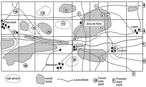
My terrain board is four by eight feet. I built terrain as shown below. Villages were marked by a one or two model houses that could each shelter a single company of infantry. Ridges or gentle high ground were built of pieces of flat styrofoam. The high ground concealed what was behind it and gave a slight defensive advantage to troops defending along the front edges. Wooded areas were designated by green card stock. Models of trees were for visual appeal only. The card stock marked the expanse and edges of wooded terrain. The Bois de Paris and other woods were traversed by a number of narrow roads. I designated roads by narrow brown strips of paper. Lasne Brook was fordable everywhere so it's course was marked by a series of simple blue paper strips.
Also note several numbered locations throughout the terrain. These are the areas where the French might appear. The Prussians would enter from the left side of the board (generally east) and try to exit the right (west) side on their way to attack the left of the main French forces. I lettered the five places where the Prussians would enter the board A, B, C, D and E.

Waterloo: The Paris Woods Scenario Part 1
Waterloo: The Paris Woods Scenario Part 2 [LW148]
Back to Table of Contents -- Lone Warrior # 147
Back to Lone Warrior List of Issues
Back to MagWeb Magazine List
© Copyright 2004 by Solo Wargamers Association.
This article appears in MagWeb.com (Magazine Web) on the Internet World Wide Web.
Other articles from military history and related magazines are available at http://www.magweb.com
