 Arctic Cities
Having Elvesgaards-Moen on the maps as a reference city (currently in 513:0810) creates confusion since it is not a port (although it is in a coastal hex). Under SE rules it is also an airbase, yet there never was an airfield here during WWII. I recommend the city be deleted entirely.
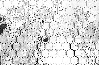
[MAP 5B PICTURED]
Kautokeino (currently in 6AA 132) is misplotted and should be in hex 513:1001. This city is 21 miles east of the Norwegian/Finnish border, 47 miles NE of Kaaresuvanto, and 64 miles SW of Alta. Kautokeino also lies at the headwaters of both the Reisen and Alta river systems, and placing the city in 513:1001 not only meets the distance requirements but shows this. (The designers of map 6A probably used a German map as their primary source; almost all German maps of the WWII era have Kautokeino misplotted.) Moving the city will also necessitate moving the road leading to it, as described below.
Arctic Roads
The Alta Kautokeino road does not cross the Alta river as shown on map 6A. The road hugs the western bank of the river and thus should run through hexes 6A:0732, 0832, 0933 and 513:0901, 1001.
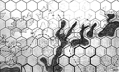
The northern coastal road seems to be off in a number of places. The Kirkenes/Tana segment hugs the coast and thus should probably run through hexes 6A:1022, 0923, 0823. The Vadso/Vardo segment also hugs the coast and should run through 0921 vice 0821. Similarly, the Lakselv/Russenes portion hugs the coast and should run through 0628 and 0528. The junction of the Kautokeino road with the main coastal road occurs at Alta vice 0732. All these road changes are illustrated on the Alta mini-map.
Additionally, the section of the road from Lakselv to Tana was an unimproved second class road (some of which was still under construction in 1940) until the German engineers upgraded it prior to Barbarossa. Some mechanism to account for this seems needed.
Continuing with the coastal road onto map 5B shows several more discrepencies. The segment between Alta and Tromso is off in several places as from Alta to 0605 the road follows the coast the entire way. The Tromso cutoff from the main route occurs at the base of the Balsfjord, thus the main road should run from 0605 to 0606. The section of the road in the Bardufoss area follows the west bank of the Bardu and should probably go from 0707, 0607, 0608, 0709, 0809 as a consequence.
Finally, the ferry between the mainland and Harstad occurs at the tip of the peninsula in 0812. All of these road changes are illustrated on the Narvik mini-map.
The alignment of the road to Bodo also seems to be off a bit. This road hugs the shore of the fjord just to the south of the city and does not make the northward loop shown on the maps. Thus, the road should go directly from 5B:1317 to 1217.
The current depiction of the area between Bodo and Narvik as trackless is not completely accurate. This area had a road running between the two cities (5B:1317, 1216, 1116, 1115, 1014, 0914, 0913, 0912, 0911), but not all of it was completed at the time of the German invasion. If circumstances required it, the road probably could have been completed given sufficient investment of time, resources, and engineering assets (the Norwegian target date for completion was 1943) and players should be allowed this option.
 Map 6A
Two additional roads in the Arctic require some discussion: the Lakselv-Ivalo (6A:0729, 0828, 0929, 1028, 1128, 1227, 1328,1427, 1527) and the Rovaniemi-Skibotten (6A:2502, 2402, 2302, 2201, 2102, 2001, 1902, 1802, 1703, 1602, 1502,1402,1303,1203,1104, 1004,0905,0805,0705,0706) highways. Both of these roads were major lines of communication for Twentieth Mountain Army and without them it may not be possible to simulate the German retreat from Finland in 1944. Both existed pre-war in some form, but did not assume major importance until improved by German engineers.
To handle the various changes to the Arctic road net made by Germany I recommend the following:
- #1 -- add the Bodo-Narvik, Skibotten-Rovaniemi, and Lakselv-Ivalo roads to the maps,
#2 -- rule these three roads, as well as the section of road from Lakselv to Tana, as unplayable until improved, and
#3 -- allow any construction unit to improve these roads at a cost of one month of time and one RP per hex.
Arctic Rivers
One large river, the Pasvikelv, was left off northern Finland/Norway. This river is the natural outlet for Lake Inaari and is both wider and has a greater flow than the Ivalojoki which is shown on the maps. The Pasvikelv River would run just east of the chain of hexes: 6A:1 325, 1324,1223,1123,1122.
The Tana River in northern Norway [6A:0624] seems to have been foreshortened. The main portion of river formed the Norwegian/Finnish border and was a good size river as far upstream as 6A:1029. The turn south into Finland shown on the maps represents a minor tributary and probably should be deleted.
The Ivalojoki River (shown flowing into Lake Inaari near Ivalo [6A:15271) is longer than it should be. The game map shows the source of the river as being in Norway, whereas in reality no portion of the river is in Norway. The Ivalojoki should probably be cut off where it reaches hex 6A:1431.
The Reisen and Raisen rivers (the first two rivers west of Alta [6A:0632] on map 5B) seem to be slightly skewed. The closest of the rivers to Alta (Reisen) actually flows into the sea at the base of the Kvaenanagen fjord (the fjord shown in the middle of hex 513:0602) Since the toad actually crosses the fjord at a ferry (which is shown on the current maps) it would seem that redrawing the Kvaenanagen fjord so it falls on hexsides 513:0503, 0602, 0603 and then displacing both of the two rivers westward one hex would be a better portrayal of the situation. This has been done on the Narvik mini-map included with this column.
The river on map 5B which is shown flowing into the Balsfjord just to the east of Bardufoss [513:0808] is incorrect. Modern maps show a river in this area, but this represents the diversion of a portion of the water of the Mals river northward in order to generate hydroelectric power. In WWII the Mals flowed into the Bardu just north of Bardufoss and this is shown on the Narvik mini-map.
Additional Norwegian Glaciers
A couple of the northern Norwegian glaciers, which show up on almost all period maps as quite extensive expanses of ice, got left off. Svartisen (5B:1420/1419) is actually the largest glacier in Norway, covering more than 200 square miles spread over two hexes. (The three contiguous glacier hexes in southern Norway represent a chain of glaciers). Blammansisen (5B:1416) is smaller (9 square miles), but is the dominant terrain feature in its hex. (John Astell agrees that Svarlisen should be added, but feels that the addition of Blammansisen may create an artificial bottleneck at hex 5B:1317 and recommends that Blammansisen's effects be shown via the use of high mountain hexsides at 5B:1416/1516 and 1416/1415 instead.)
Many more glaciers are present in northern Norway, and in several hexes they are the dominant terrain type (5B:1012, 1113, 1010, 1111, 1413,0505,0402,0401,and 6A:0430), but the individual glaciers are, for the most part, small and separated from each other by valleys and mountains over which movement would be possible.
Rybachy Peninsula, Hexes 6A:1219 and 1119 (the western half of the Rybachy Peninsula) are shown on the game maps as Finnish owned until the conclusion of the Winter War. This is not strictly true as the Soviets owned a narrow strip of the eastern coast along which ran a road used to supply the Rybachy garrison.
Accordingly, the Soviets should probably be allowed to move and trace supply through hexes 1219 and 1119 (but not end movement in those hexes) while at peace with Finland.
Rombaksfjord. The current depiction of the Narvik area does not show that there was a rather large fjord (Rombaksfjord) just north of the rail line which reached to within 8 miles of the Swedish border. The coast road north from Narvik also crossed this fjord at a ferry. At a minimum I think 5B:0810/0911 should be a sea hexside to reflect this.
Langfjord. The current depiction of the area just north of Alta seems somewhat skewed. The Langfjord (the large inlet in hex 6A:0532) actually extends to within four miles of both the Burfjord and Jokelfjord (the two inlets in hex 5B:0602). Additionally, hex 5B:0401 (6A:0433) should probably be mountain vice rough and 6A:0432 (currently clear terrain) should probably be rough. Both of these hexes are very rugged, with the peaks in 5B:0401 even more precipitous than in the mountain hexes to the south (about a third of 0401 is also glacier covered. Both of these are corrected on the mini-maps included with this column.
Additional Arctic Islands
Add the islands of Grytoy (5B:0611, rough) and Rolla/Anclorja (5B:0711, rough). Additionally, 6A:2904 shows the outline of an island, but the entire hex is colored sea blue. This is the island of Morshowez and should be clear terrain.
Ambiguous Hexes
The current depictions of hexes 6A:0430, 5B:0406, 5B:0612, and 5B:0715 are ambiguous. (The last hex listed is a worse case than usual as, even in modern times, if you want to get from Hinnoy (the eastern island) to Austvagoy (the western island) you have to first travel to Langoy (the island to the immediate north) or take the Narvik ferry since the mountains on either side of the strait between the two islands rise almost sheer from the water.)
Clean up the first by redrawing Kvaloy island (the island which includes Hammerfest) to fit entirely within hex 6A:0330. At the same time redraw the adjacent coastline to run through hexes 0531, 0530, 0429 thus freeing up hex 0430 to show the island of Seilland (rough terrain). 5B:0406 (Tromso) can be cleaned up by deleting the portion of Ringvassoy island which appears (the large island which intrudes into the northern portion of the hex). 5B:0612 can be cleaned up by deleting the portion of land in the SE portion of the hex, leaving the peninsula intact. The last of these can be corrected by deleting the portion of the island in the eastern part of the hex (Hinnoy Island). All except the last of these can be seen on the attached mini-maps.
More Touring the Europa SeaShore
Back to Europa Number 10 Table of Contents
Back to Europa List of Issues
Back to MagWeb Master Magazine List
© Copyright 1989 by GR/D
This article appears in MagWeb (Magazine Web) on the Internet World Wide Web. Other military history articles and gaming articles are available at http://www.magweb.com