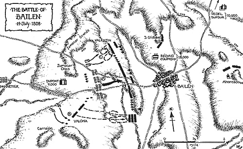
The topographical and deployment data for the Bailen chapter in "Battle Studies in the Peninsula" were largely taken from Oman and compared to a more detailed version in "Researching & Dragona" - a reputable Spanish Military History publication - which was provided by the authors from their own research in Spain. Dr Esdaile has advised that the dispositions are incorrect for the Spanish defensive line and that the French attacks were made from more advanced positions than those shown. He states that the two Spanish divisions (under Coupigny and Venegas) were "somewhat intermixed" which he logically suggests testifies to "the extent to which Reding was taken by surprise". Oman indicates that Reding was somewhat surprised that Dupont was marching on Bailen and not being engaged by Castattos nearer Andujar, which would have allowed the Swiss General to take him in rear. However, he does state that Reding's men were rousing themselves from bivouac and were thus able to take up the positions which Oman and R & D indicate and which we thus assumed were correct.
Dr Esdaile tells us that the Spaniards' right flank was on the Zumacar Grande, as shown in "Battle Studies in the Peninsula" page 103, with their right on El Cerrajon. However, he indicates that their centre was the internal angle of a very obtuse "V" with Bailen town just behind its apex. He further tells us that the French attacked downhill from the position that our map on page 103 shows as occupied by the Spanish centre. It would appear that our map indicates the high ground as a little further in front of Bailen than it actually is. He recommends a reference ("El Ejercito de Andalucia en la Guerra de la Indpendencia", by C. C ceres Espejo, for its maps and photographs).
We have obtained a copy of this and have asked Derek Stone to produce a map indicating the correct dispositions; both maps are shown below. Unfortunately we have not been able to obtain permission to reproduce the photographs. Espejo's Map indicates that the right of the Spanish line was on the lower slopes of the Zumacar Grande, whilst the left only reached the Cerrajon when the battalions furthest to the left advanced against Prive's cavalry.
This is the first intimation we have had that Oman's version is so far at fault and we have read no other narratives that tell of the French attacking downhill. To my mind, it suggests that the Spanish were in a less strong position than other sources indicate and their success thus the more creditable - although one must bear in mind the piecemeal nature of French attacks and the relative inexperience of their troops.
Once more we are indebted to Dr Esdaile and thank him for his time and trouble in clarifying the position.
Napoleonic Peninsular War
Back to Battlefields Vol. 2 Issue 1 Table of Contents
Back to Battlefields List of Issues
Back to Master Magazine List
© Copyright 2004 by Partizan Press.
This article appears in MagWeb.com (Magazine Web) on the Internet World Wide Web.
Other articles from military history and related magazines are available at http://www.magweb.com