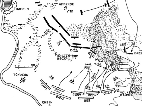
Notes on the Sketch Map
The map shown on the opposite page is based on contemporary measurements and shows the marshy ground and woods as they existed at the time of the battle. The location of the marshes was the reason why the French attacked Cumberland's left wing only.
Abbreviations used in the map
French Army
- AA Advanced position of artillery during battle (noon)
Arm Armentieres
Bro Broglie
Cav Cavalry Division
Cha Brigade Champagne
Chev Chevert
Cont Contades
Eu Brigade d'Eu
Re Brigade Reding
Res Infantry Reserve
Army of Observation:
-
1A, 1B, 2, 3, 4 Hanoverian Batteries
Bre Breidenbach at noon
Dach Dachenhausen at noon
Topography:
- Vo. Voremberg

Back to Seven Years War Asso. Journal Vol. X No. 4 Table of Contents
Back to Seven Years War Asso. Journal List of Issues
Back to Master Magazine List
© Copyright 1999 by James E. Purky
This article appears in MagWeb (Magazine Web) on the Internet World Wide Web.
Other military history articles and gaming articles are available at http://www.magweb.com