 Heading west on I-64 from Monticello, we made for Skyline Drive, which runs thr length of SNP. The exit ramp comes quikly at the top of a long hill, then curls around and under the interstate, dropping you off on a smaller road.
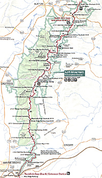
Map by National Park Service. We toured the southern third of the park, from Rockfish Gap to Swift Run Gap.
Jumbo Map of Southern Section of Park (extremely slow: 378K)
At the first gas station, a Chevron I believe, turn right into the parking lot and drive behind the gas station, descending into a gravel parking area. You'll find a tourist information station next to a souvenir shop. It's staffed by two of the friendliest and knowledgeable people you'll meet, as well as rack upon rack of pamphlets and maps that will make your trip a greater pleasure--whether you're heading north as we did, or heading south as someone else might. I must apologize that I quite forget their names at this point, but whoever was staffing the Rockfish Gap Tourist office on September 12, 2002, you made our trip all that much brighter.
Also inside this station is a full-size manikan of Robert E. Lee, so this is the time to snap a photo with him, as well as a wonderful 10'x6' diorama of the park. It's a real beauty, under glass, with the deep folds of the green mountains puntuated by splashes of color representing different plants and areas, as well as roads, lakes, and so on. It really is a work of art.
The fellow staffing the station told a funny anecdote. Let's see if I can do a better job remembering the ancedote about the diorama than the teller's name.
Evidently, a different woman was staffing the tourist office some time ago. She was, how should I say, not a very petite woman. In fact, she was a very large woman. In any case, while she's minding the office, a lady rushes into the office and complains somebody was after her. A minute or so later, a man staggers in, rather unkempt and dissheveled, and obviously intoxicated. This drunk was the one pestering the lady and had followed her into the office. The tourist office woman phoned for help.
Seeing two women, the object of his desire as well as the very large woman, both yelling and screaming at him, his courage fled, and he soon left the building. After composing herself and checking to see the coast was clear, the lady offered her thanks and left as well.
Shortly thereafter, the drunk returned. This time, only the large woman was in the office. There ensued another bout of shouting, with the woman screaming at him to be gone, and the drunk hurling insults and abuse as he stormed around the office and ended next to the diorama.
At this point, while looking at the diorama, he yells, "Hey! I'm hungry!" Then, he says to the woman, "Why don't you get off your goddam fat ass and fix me a salad!"
This triggered something in the woman, who promptly chased him until he fell over, and then she sat on him until the local police arrived and dragged him off.
 Shenandoah National Park
Shenandoah translates as "Daughter of the Stars," so says the Fodor's guidebook and SNP stretches 105 miles or so from Rockfish Gap in the south to Front Royal in the north. Some 60 peaks make up the range that Skyline Drive writhes through them. The speed limit is 35 miles per hour, though I imagine in the height of summer or on fall leaf-watching weekends, the crowds drop that down. We faced extremely light traffic, and usually were able to keep 35mph through the twists and turns.
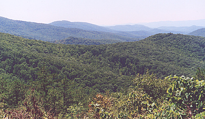
Typical of the scenes inside the park.
Parking areas and turnoffs appear on the left and right side of the two-lane road, although be warned that sometimes it is almost impossible to see around a curve to check on-coming traffic if you intend to enter one of these spectacular viewpoints. Most of these overlook the vistas, so you'll be oohing and ahhing at Nature's glory.
John Lederer was the first European explorer to reach the area in 1669 and leave a written record about the land and natives. In 1716, colonial Governor Alexander Spotswood led an expedition across the mountains and instituted a generous land grant program to encourage settlement before the French arrived. By 1730, diseases had killed off most of the natives an by 1790, 67,000 Europeans-turned-Americans inhabited the region.
In 1926, Congress authorized SNP on the condition that no federal dollars would be used to purchase land. Virginia passed an act of condemnation requiring all landholders to sell to the state. State and private monies bought the property, although not until after court battles from landholders.
The Federal government conmenced building Skyline Drive on July 18, 1931, in part because then President Hoover had a fishing camp in the area. In 1933, the Civilian Conservation Corps established two camps, later expanded to 10 camps, and started to build more roads, trails, park buildings, and other projects. The central section of Skyline Drive was opened in 1934. Officially, the park was established on December 26, 1935, but it asn't until July 3, 1936 that FDR arrived to dedicate the park.
 Trails criss-cross the park, including the Appalachian Trail, and other parking areas sit near trailheads. We hiked Blackrock Trail, a one-mile, relatively easy walk to Blackrock Summit. You stop at the aptly named Blackrock Summit Parking Area (mile marker 84.8), and head up the mountain. A sign at the trail head gives you a rough idea of the layout, and additional signs at trail crossings point you in the right direction. It's pretty hard to get lost.
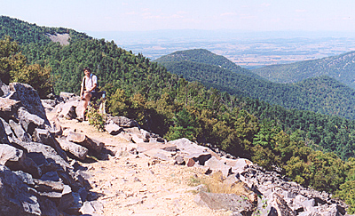
Don't Jump! MagWeb.com CEO Russ Lockwood takes a breather on the side of the trail.
On a crisp autumn day -- one should never say "fall" while hiking towards a summit -- it was a glorious little walk to the summit, which was one of those bare rocky areas you normally see in the distance. It looks as if the rocks were cracked by hand and piled there, but they are indeed, naturally occurring geologic formations, so says the sign. From a distance, across a valley to a neighboring hill, they look so small, but close up, there's some pretty good-sized rocks.
A good stiff wind kept the bugs away, and that made it even better, although on the return through a parallel trail, we headed into some swampier areas and picked up a train of some bugs or another that lasted all the way back to the parking lot.
We stopped at the Wayside (mile marker 79.5 or so), a combination snack shop and gift shop, for a little refreshment. Nearby is Loft Mountain Information Center, along with a gas station, campground, picnic area and other amenities.
As it was getting late, remember, we spent the morning at Monticello, and you shouldn't rush through SNP. I mean, we stopped at just about every vista turnout between Rockfish Gap and Loft Mountain. We wanted views, and SNP delivered.
I should point out that we experienced just a small portion of the entire park. There are many trails in the northern half of the park, including to the tops of mountains and to the various waterfalls (although 2002 was a severe drought year, so I imagine the waterfalls were not as spectacular as in previous years).
 We headed west on rte 33 out Swift Run Gap (mile marker 65 or so), heading towards Harrisonville, which our guidebook noted was right on I-81 and had a number of hotels, restaurants, etc. It's about 20 miles from SNP. Although we did not return to SNP, the $12 we paid allows you back in the park for up to seven days.
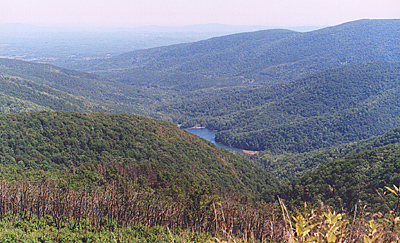
Moorman's River Overlook, presumably to a lake in the path of Moorman's River.
Harrisonville
The town, or at least the commercial area adjacent to I-81, contains the usual hotel, restaurant, and plazas that crop up along the highway. Smaller motels are available closer to the park, but since we were planning to head north on I-81 in the morning, it seemed a good place to stop. The Hampton Inn was full, so we stayed next door at the Marriot Courtyard ($89).
We found an excellent Mexican restaurant a couple blocks over from the hotel on Neff Ave. called Jalisco. They have three in the area. I can't remember which one this was, but it was superb.
After a little shopping in Books a Million, a chain not found in our area of NJ, we retired to the Marriot. The next morning, it would be off to New Market and the ACW battlefield.
Back to List of Historic Sites
Back to Travel Master List
Back to MagWeb Master List of Magazines
© Copyright 2003 by Coalition Web, Inc.
This article appears in MagWeb (Magazine Web) on the Internet World Wide Web.
Other articles covering military history and related topics are available at http://www.magweb.com