 It is another beautiful day (9 December), although the forecast predicts rain and lots of it.
The temperature is 60F and will rise to 75F by afternoon before the rain arrives. This
inspires me to make two more stops before driving west to Louisiana. My first tour will
be Champion Hill and the second Big Black River.
I had bought a campaign map ($4.25) at the park yesterday and decided to tour the above-mentioned
battlefields that are located along the route from Jackson to Vicksburg on I-20.
Terrence J Winschel, the current historian at the Vicksburg National Military Park, wrote
the map’s narrative and provided good directions on how to explore the battlefields of the
Vicksburg campaign. I also bought his pamphlets on Champion Hill and Port Gibson
(each $0.50) to supplement the map.
It is another beautiful day (9 December), although the forecast predicts rain and lots of it.
The temperature is 60F and will rise to 75F by afternoon before the rain arrives. This
inspires me to make two more stops before driving west to Louisiana. My first tour will
be Champion Hill and the second Big Black River.
I had bought a campaign map ($4.25) at the park yesterday and decided to tour the above-mentioned
battlefields that are located along the route from Jackson to Vicksburg on I-20.
Terrence J Winschel, the current historian at the Vicksburg National Military Park, wrote
the map’s narrative and provided good directions on how to explore the battlefields of the
Vicksburg campaign. I also bought his pamphlets on Champion Hill and Port Gibson
(each $0.50) to supplement the map.
The battlefields are not well identified and it is necessary to have a good idea of where to
go before attempting to visit these locations as I found out.
 Once again I wish that Allie could navigate, as it was difficult to spot some of the sites
described by Winschel. I do not fault the directions, but rather the need to pay attention
to the roads that meander through some heavily wooded areas, over hills and lots of
curves. Traffic was light and I was able to make many stops along the side of the road
wherever I could find a decent parking spot as the roads lacked shoulders in many places
and often were several yards above the surrounding land.
Once again I wish that Allie could navigate, as it was difficult to spot some of the sites
described by Winschel. I do not fault the directions, but rather the need to pay attention
to the roads that meander through some heavily wooded areas, over hills and lots of
curves. Traffic was light and I was able to make many stops along the side of the road
wherever I could find a decent parking spot as the roads lacked shoulders in many places
and often were several yards above the surrounding land.
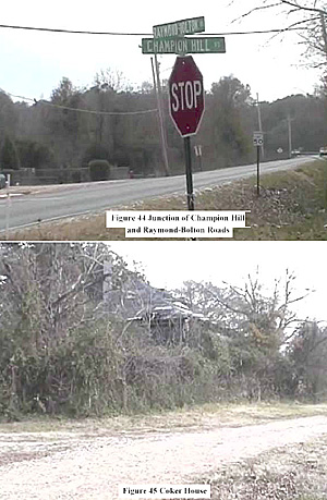
For Champion Hill, I took Exit #27 off I-20 and drove through the town of Bolton to the junction of the Raymond-Bolton and Champion Hill Roads. I turned right (west) on to Champion Hill Road and drove to the junction with the (North) Chapel Road, where I turned left (south).
The Chapel Road forms the eastern boundary of the battlefield, and Champion Hill Road is the northern boundary. I drove along the former to the junction with the Billy Fields Road (old Middle Road and Jackson Road), which was the route taken by US Generals Carr and Osterhaus to Champion Hill. The tour route continues down Chapel Hill to the Old Raymond Road (Route #467). There is no sign indicating that the east-west road is indeed #467, so I just turned right (west) and hoped that it was the correct road to take to Jackson Creek. Fortunately it was and I soon found the next site on the tour. Many of the ACW homes identified on the map are gone with the exception of Coker House, which is difficult to recognise as it is concealed by heavy growth, trees and vines.
The next stop was the plaque marking the spot where CS General L Tilghman was killed
by a US artillery round while defending the approaches to the south Bakers Creek bridge
on the Raymond Road.
 This is difficult to see as it is on the north side of the road
amongst the trees lining the roadside. Looking eastward, it is possible to make out the
land around the Coker House, where the US artillery was positioned.
This is difficult to see as it is on the north side of the road
amongst the trees lining the roadside. Looking eastward, it is possible to make out the
land around the Coker House, where the US artillery was positioned.
The Raymond Road continues west to the junction with the Buck Reed Road, which forms the western boundary of the battlefield. CS General WW Loring and his division were unable to maintain contact with the rest of the CS army so used a plantation road to make their way back via a circuitous route to Vicksburg.
I turned onto the Buck Reed Road and travelled along it to the Champion Hill Road again. At this point I had driven around the southern end of Champion Hill without being able to actually travel along the hill. The land is privately owned and hard to access as the Ratliff Road is not reachable (actually non-existent now) without permission from the owner. Champion Hill Road is the western end of Billy Fields Road, and I turned onto the latter to find another of the few historical markers of this battlefield.
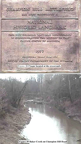
The crossroad plaque is easy to miss as it is tucked in amongst the trees on the right (north) of the Billy Fields Road, heading west to Champion Hill Road, where it meets Johnson Road. The land is thickly wooded here and it is difficult to imagine that this was the scene of heavy fighting. Again this is based on the current status of the area.
The next stop was the Baker Creek Bridge on Champion Hill Road. This was not open to the CS army as the right flank of the US Army had control of it and thus threatened to turn the Confederate flank. The only escape route was the bridge on the Raymond Road to the south.
I drove along Champion Hill Road to where the Champion House stood and now is occupied by a church. The Farr Road forms a T-junction with Champion Hill Road just east of the church. The house was destroyed after the war, just another indication of the many missing landmarks on this battlefield. Champion Hill and the surrounding terrain are visible along the road, although much of the land is now covered by trees so it is difficult to see the CS defensive positions.
I drove back to Bolton and returned to I-20 for the short ride to Exit 11 and the small town of Bovina. I got lost trying to find the intersection of Warrior Lane and Highway #80 as there are no signs to #80 and I missed the turn at the fork in the road east of town.
 At this point Warrior Lane splits and the Bovina By-Pass begins as the right-hand fork
(heading east). After a few minutes of muttering, I turned around and went back to the
town and just took #80 east (you can see #80 as there is a road bridge over it into town
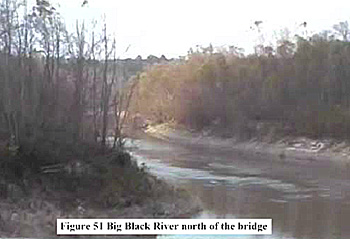
from I-20). I stopped east of the modern bridge over the Big Black River and took some
video footage of the railroad bridge and surrounding fields.
At this point Warrior Lane splits and the Bovina By-Pass begins as the right-hand fork
(heading east). After a few minutes of muttering, I turned around and went back to the
town and just took #80 east (you can see #80 as there is a road bridge over it into town
from I-20). I stopped east of the modern bridge over the Big Black River and took some
video footage of the railroad bridge and surrounding fields.
One look at the ploughed fields near the modern bridge gave me a good impression of what the US troops had to cross in order to assault the CS defensive positions. The fields were dry, but deeply furrowed and obviously the ground could quickly turn to a thick quagmire of mud. Even the riverbanks were of soft soil and it is no wonder that the CS soldiers had difficulty crossing the river.
Then I headed west on #80 to the Vicksburg National Military Park. I stopped briefly at the park to walk Allie and check the map. The clouds were now thick and dark overhead, a clear foreshadowing of the expected rainstorm.
This marked the end of my planned tour of the various ACW sites. It had been an enjoyable jaunt despite my navigation woes (all minor). I continued west to Monroe, La before the rain “encouraged” me to stop for the night.
Back to Sabretache # 6 Table of Contents
Back to Sabretache List of Issues
Back to MagWeb Master Magazine List
© Copyright 2003 by Terry Gore
This article appears in MagWeb.com (Magazine Web) on the Internet World Wide Web. Other articles from military history and related magazines are available at http://www.magweb.com