Editors Note. Wes was kind enough to send in the following article with examples of his maps.
I thought I'd indulge myself, and send you a few sample maps, to give you an idea of what the program can do, and what its output looks like. I poked around on the internet and, to my surprise, found only one other product -- Campaign Cartographer ($80.00, I think}- which does anything like GameMapr. There are a number of expensive cartographic mapping systems out there (GRASS, for example), but no cheap programs that would let a wargamer create simple "SPI" style "ridded maps. Campaign Cartographer looked pretty good, although it seemed to be mostly bitmap-based, and tailored for fantasy role-playing. Also, the product's website has been down lately. All of the maps below have been embedded into the Word 6.0 document you are reading.
They are all the default 6" X 6" size, so that they will fit nicely onto a page; however a map can actually be up to 100" X 100". I could have made a map arbitrarily large, but this seemed like a reasonable limit.
Gamemapr is designed for three types of maps, which are the kind I tend to need.
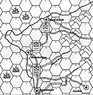
The first is a "miniatures campaign map", where there is a grid of some type (usually hexagonal), and the ``wargame counters" shown on the map represent forces which can be moved about Each such force can have notes anached to it (one of the properties of a symbol object). A map such as this is ideal when embedded into Excel; the referee can actually embed one map per turn right into the main worksheet, and shrink the cell containing it down to a small as desired. The other paperwork-related aspects of the campaign can then be recorded in the other cells of that worksheet, or on separate worksheets. Such maps can also be copied and distributed to the players in the campaign, turn by turn.
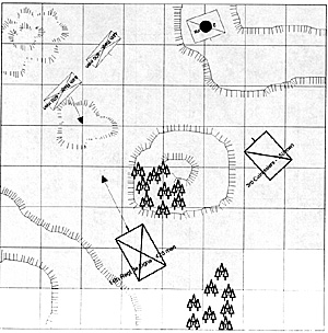
The second is a "battle diagram" type of map, which shows the layout of forces in a particular banle. The "force markers" making up each army can be rotated, with arrowed lines wed to indicate how they are moving. This is useful for writing articles; the diagrams can be inserted into the article directly
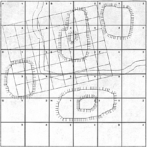
The third type is a combination of the above two, a sort of "Charles Grant" type of map, where the map is "ridded into numbered squares, and the forces of each player are allowed a certain amount of free-fomm movement each tum When forces come close. the "game table" object (a small, rotateable grid) can be used to mark off the wargame table on which the battle will be played.
If anyone would like a copy of GameMapr as it is now (the help function may be ready by the time this is published), they can e-mail me at rogers_wes@msn.com, and I'll e-mail them the .exe file and associated registry file. The .exe is about 700KB.
GameMapr runs on the Windows 95 operating system, it also runs under Windows NT, but some aspects of performance are not quite the same as under Win 95.
The following pages show simple examples of each type of map.
Example 1 A miniatures campaign map. This map uses a hexagonal grid, with a standard "rowcolumn" numbering system. Although GameMapr supports color, I have minimized its use here because I know MWAN is black and white.
The coastlines use the "triple line" drawing line, which allows a "port", "starboard" and "middle" line to be drawn, with options to hide any of the three lines. In this case, the starboard line is shown as a thick blue line, the middle line is shown in black, and the port line is hidden. The roads are triple lines with the middle line hidden. This line type makes drawing of roads, rivers, coastlines, and dual borders easy.
Contour lines are supported, drawn by dragging the mouse (standard or "fanned" lines available).
Force marers can be dropped on maps, and text rotated.
GameMapr can superimpose a game table on a map ala Charles Grant. It also supports large maps (16 sheets of paper).
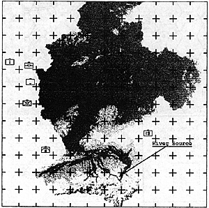
Finally, GameMapr has basic support tor bitmaps. GameMapr's bitmaps by default have a transparent color changeable by the user) which allows bitmaps with irregulat outlines to display nicely. Unfortunately, I have noticed a lot of trouble printing transparent bitmaps; the effects seem to vary from printer to printer.
The map below shows a "Rhine basin" .bmp file I pulled offthe web (I'd give credit to the author, who obviously did a great job, but I can't remember where I got the file); it has been made opaque for better printing. I have also overlaid it with a grid (cross-hair this time). This shows how you could take a large .bmp file and use it for a backdrop for a wargame map.
The NATO military symbols, by the way, are from a true-type font I downloaded from the web, from Tom Mouat's "mapsymbs" website. If you are into fonts, check out this site' He's got a cornucopia of free fonts to download, military and science fiction.
Sample Maps


Back to MWAN #94 Table of Contents
Back to MWAN List of Issues
Back to MagWeb Magazine List
© Copyright 1998 Hal Thinglum
This article appears in MagWeb (Magazine Web) on the Internet World Wide Web.
Other military history articles and gaming articles are available at http://www.magweb.com