None of us have a large enough table. Even if we had room for a huge permanent wargames table, most of us could not reach more than three or four feet at most. We can play on the floor, provided we are careful of model trees and houses, and don't mind sore knees. We can hire a gymnasium for really big battles. However large our playing area, however, it still has edges. A useful system, which I call "Abstracted Scale", can be of help to us in certain situations. Let me explain.
Wargamers conventionally amply a standard ground scale. This may vary from game to game, but is constant within that game; an inch represents 10/50/100 yards all over the table. There is no reason, however, why this should always be the case. Provided we clearly define separate "zones" on the table, we can compress a large area of ground into a much smaller space. This works well with games involving a static position, since there will be little pressure to other zones in the course of an action.
For instance, let us take a game involving a small fort or outpost under attack. If the work is designed for a garrison of a company or less, it is likely to be no more than 100 feet wide, and very probably smaller. This means that the range of a flintlock musket - some 200 yards - is six times the width of the fort; as we advance in time, this ratio increases substantially, and in all periods, artillery will have a range dozens of times greater than the width of the strongpoint. Therefore, if we place a model fort 6" square on the table to represent our beleaguered post, we will need a field of 3 feet on all sides to represent a 200 yard land of musket range; if the fort is 12" across - still by no means a large model - that field of fire is 6 feet in each direction. And I'm not talking about artillery or breech loading rifles or even primitive old rifled muskets! We have a number of choices at this point.
- (1) We can accept the situation as it stands, and play on a very large table.
(2) We can reduce our scales, and accept that if we wish to use a normal sized table, we'll need a very small fort. This presents us with a game about firepower effects, with little emphasis on the actions of the men inside the strongpoint.
(3) We can allow attacks only from one or two sides, and place the fort at one edge or corner of the table.
(4) We can curtail visibility by night, fog, or thick jungle.
(5) We can say that, yes, the scale is 1" to 10 yards or whatever, but the fort is overscale since it's a nice model, etc. This is a typical response used by most of us at one time or another, but it's only half the answer.
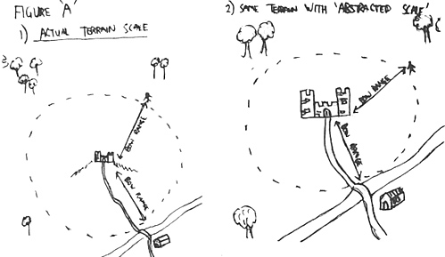
(6) We can "abstract" the scales. By this I mean we use a strict scale for those areas in which we are chiefly concerned, and which are likely to be centres of action.
 The scale itself should be determined by the number of figures and the complexity of the scenarios - obviously its absurb to have a man-to-man figure scale and a 1" = 50 yards groundscale, and likewise a 1-50 figure scale with a 1" to 1 yard ground scale. A general rule I use is that in 15mm each man represented by the figure should approximate to the number of yards per inch of the wargames table. Outside these selected "combat zones" we have areas through which we- can expect men to move but not to engage in close combat. In our "fort" scenario, for instance, we might look at the activity within the fort in some detail as a potential "combat zone". Surrounding the fort area series of imaginary concentric rings, representing weapon ranges.
These need not be too detailed; "close range," "long range" and "artillery range!' would do the job for us in most instances. Now, we can work out how wide each of these rings would be, but we do not need to display that distance accurately on the table. All we need to do is calculate the time required to cross from one ring into another, and the approximate casualties for that crossing. In this way we can place our fort in the centre of a table and represent distance from it not by orthodox time scale distance, but by dividing the board up inyo symbolic areas whose size we know. Diagram "A" shows what I mean. This is a system I have used with success in my "Forlorn Hope" siege rules, where no measured moves are used at all; troops move instead from "one area" to another, each area being defined as a piece of ground with it's own terrain characteristics.
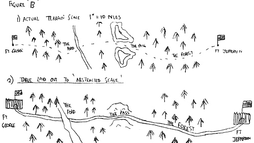
 This system works well in a game of the "march" type. Let us assume that our column has to pass several obstacles, any or all of which might be defended, before it reaches its goal. The length of this march might be five miles, fifty or five hundred; by abstracting the scale we can, however, have all the various obstacles on one table, probably quite a long one. The key thing to note is that there must be enough distance on the board between these features that model soldiers do not stray from on obstacle into another during the course of an action; it would not do for a unit routing from "the ford" to arrive at "the pass" on the next turn when the two are supposedly 15 miles apart! Partitions of dense forest, mountains, etc. are good for delineating these boundaries; figure "B" shows this, showing five potential scenes of action on one long table.
The "Abstracted Scale" does not work in all -- or even most -- wargames; it certainly doesn't fit very well into a flowing, manoeure-oriented open battle. When the scenario calls for a reliance on static positions and key terrain features, it works very well.
Back to MWAN # 20 Table of Contents
Back to MWAN List of Issues
Back to MagWeb Magazine List
© Copyright 1986 Hal Thinglum
This article appears in MagWeb.com (Magazine Web) on the Internet World Wide Web.
Other articles from military history and related magazines are available at http://www.magweb.com