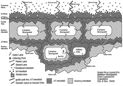
Here's an interesting diagram I found while doing some research.
The book I was perusing was "The War in the Desert, The Eighth Army at El Alamein" by James Lucas. Copyright 1982, ISBN 0-8253-0153-X. The diagram is apparently from another reference, although I could not find the complete document listed in the bibliography. The title of the diagram in the book reads "From Lessons from Operations Oct. and Nov. 1942 (M.E.T.M. No. 7)."
The "Company Strongpoints" are 300 meters deep by 700 meters wide.
The "Scattered Minefield" is 300 meters deep. It was not clear to me what was meant by the "scattered minefield." I wasn't sure if these was a mixed minefield or a reference to terrain specific laying of mines in obvious approach lanes, dead ground, etc.
The "Infantry Minefield" appears to be band of mines with an undocumented depth that are laid at the edge of the AT minefield. They appear to be laid between the AT minefield and the Scattered minefield.
The "AT Minefield" is listed as 300 meters deep.
There are Guide Lanes through all the AT minefields.
The "Double Apron or Damert Wire" is 100 meters in front of the Company Stongpoints.
There was no explanation of what Damert Wire is.
The distance between the forward strongpoints and the rear strongpoints is listed as 600 meters, measured from the back of the front strongpoint to the front of the rear strongpoint.
The battalion HQ is co-located with the company in the rear strongpoint.
There are electric mines in the AT minefield, shown positioned in front of the guide path. Each company has a "Detonation Post" located in the strongpoint. I did not show the wires and detonation posts since the diagram was getting too cluttered.
There are recon (Recce) Lanes through the wire and minefields from each forward company strongpoint. There is a "Secret" Lane from the center strongpoint. All company strongpoints and the artillery area have "Open Lanes" connecting the positions and leading to the rear.
The diagram shows the strongpoints, the AT minefields and the dummy minefields as having "Wire boundaries". I take this to mean they had some sort of wire showing these boundaries, but it wasn't clear whether this was just a boundary wire or some sort of defensive barbed wire.
I thought some of you that do skirmish-level WW II gaming might find this interesting.
Map

Back to MWAN # 125 Table of Contents
Back to MWAN List of Issues
Back to MagWeb Magazine List
© Copyright 2003 Hal Thinglum
This article appears in MagWeb.com (Magazine Web) on the Internet World Wide Web.
Other articles from military history and related magazines are available at http://www.magweb.com