In late June 2001 I conducted a seven-day, self-guided driving tour of Indian Wars and other Western history sites in the Upper Plains/mountain region of the United States (to include northern and eastern Wyoming, western South Dakota, and adjacent areas of Nebraska and Montana). As an aid to the wargamer interested in this period of history, this article rates eight of the 16 major sites I visited in terms of:
- 1) their relevance to the Indian Wars and/or the era of major Western settlement (ca. 1850-1880)
2) quality of interpretation and facilities of interest to the historical gaming community, and
3) overall quality of the experience for the potential visitor.
Part I of this article, wherein another eight site were reviewed, appeared in a recent issue of MWAN. Site ratings run from one ace (*), meaning the worst, to four aces (don't-miss).
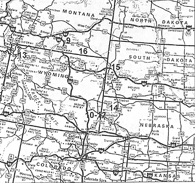
The general location of each site can be found on this Rand McNally road map the numbers thereon correspond to the order which the sites are reviewed below. The reader interested in putting together a tour of his or her own is encouraged to research specifics such as street addresses, hours of operation, admission fees, etc., in one of the many available hardcopy travel guides, in materials provided by the relevant Chambers of Commerce, or on the Worldwide Web.
 9. LITTLE BIGHORN NATIONAL BATTLEFIELD, MT (* * * *):
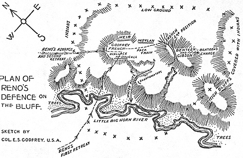
Not even a semi-serious student of western military history can afford to pass up a visit to this site. I arrived on a blazingly hot day, 25 June 2001. This was the 125th Anniversary of the famous Sioux, Cheyennes, and Arapaho scalpfest-which in hindsight proved to be almost as much the Indians' last stand as Custer's. While a spirit of political correctness has been making inroads at the Battlefield for a couple of decades, National Park Service interpretation is actually much superior to that provided during my last visit in 1976. The exhibits in the museum section of the Visitor's Center been greatly expanded and better labeled, NPS has opened a paved road running along the ridge all the way from Custer Hill, via Weir Point, to the site of the Reno-Benteen siege total of some four miles. RenoBenteen, by the way, is a must-see for those seeking to gain a real understanding of the battle as a whole.
A huge prairie fire swept Custer Hill in the mid-1980s and uncovered a great number of artifacts cartridge casings, bridle bits, belt buckles, arrowheads, and such-whose existence had been previously unknown. This unexpected bonanza made possible a more objective, forensic examination of the route, pace, and general circumstances of Custer's immediate command than had been possible before. While subsequent fieldwork strongly suggested answers to some of the more stubborn mysteries, it also served to sustain some of the sharpest controversies concerning both white and Indian actions on that fateful day.
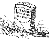 The NPS guides I met seemed well briefed on the findings of the various studies, though both they and the numerous civilian volunteers helping out at the Anniversary were more than willing to throw in their personal perspectives as well-some of them distinctly idiosyncratic. We did happen to meet the great-grandson of 1 SGT Edwin Bobo, who died with Company "C" while holding the reverse slope of Custer Hill against an assault by Crazy Horse. The hard-bitten old veteran would, in any event, have stood in sharp contrast to his overweight, quiet, somewhat befuddled-looking, whitecollar descendant--a New Englander in his 40s who had never been to the battlefield before.
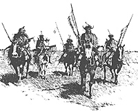
LBHNB is located on the great Crow Indian Reservation in southeastern Montana, and the Indians clearly dominated the Anniversary observance. There was an exciting all-tribes ride-in at 8 A.M., which saw 60-80 mounted Plains Indians sweep past Custer Hill. Indian religious ceremonies were held throughout the day on the nearby site of the planned Indian Wars Memorial, the Memorial will feature an impressive piece of bronze sculpture when they get it done. Here and there, Crow teenagers showed off the gorgeous plumage and buckskins of their traditional tribal dress for the cameras of tourists, in exchange for tips.
Highlight of the day for me lay in getting to meet several well-known authors of Custer booksincluding Dr. Robert Utley, former Chief Historian for the National Park Service, whose recent rereadings of Indian eyewitness accounts of the battle have caused him to reevaluate his earlier dismissal of these sources as unreliable. Another "plus" over 1976 is that the NPS has cleaned up the tiny National Cemetery immediately adjacent to the Visitor's Center. Here are buried a surprisingly high number of figures connected with the battle, including MAJ Marcus A. Reno (whom Custer partisans think a villain) and the Crow scout White Man Runs Him, who predicted Custer's demise to his face. Finally, NPS has laid out a half-mile walking trail leading from Medicine Tail Coulee and the valley of the Little Bighorn
 River up toward the Visitor's Center-along the route believed to have been taken by a portion of Custer's battalion as it recoiled from the river ford and its ill-fated effort to strike the Indian village in the flank.
NPS still has its work cut out for it at LBHNB. The bookstore is still miniscule for an important, heavily trafficked site like this one, and the stock is selected with a perhaps over-strict eye to Native American sensibilities. No running water was available during my visit, in compensation the rangers provided only a single, 10-gallon Thermos jug of chilled water and a stack of paper cups for their estimated 1,200 guests! Finally, one's esthetic sense cannot help but be profoundly assaulted when one exits the main gate of the facility only to come face-to-face with a tacky, Crow-run motel/gift shop/gas station/Kentucky Fried Chicken complex. Your tax dollars at work.
If you go, be sure to devote at least half a day to the LBHNB, in order to do it justice. Look beyond the superficial inadequacies with respect to facility to the elemental drama, even passion, of the place. Take advantage of the new spirit of balance in interpretation currently in evidence, but reserve the right to make up your own mind as to the rights and the wrongs of things. Above all, walk the field in silence and look around-hard-in an attempt to capture the atmosphere of that fateful afternoon more than a century and a quarter ago. You'll be glad you did.
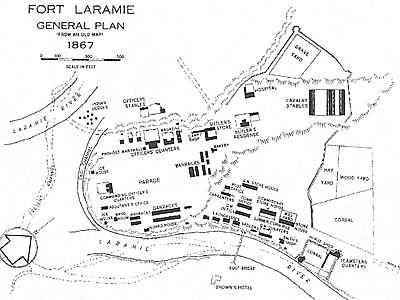 10. FT. LARAMIE N.H.S., WY (* * *)
Like a number of other prominent western forts, this one was created on the basis of a struggling 1830s-vintage fur trading post. Long since converted to an "open plan" fort which relied solely on the strength of its garrison for protection, Ft. Laramie had once been stockaded. Today it represents the most complete and history-laden of western forts. In the original Sutler's Store-the oldest commercial building in Wyoming-belly up to the very same timeworn, heavy wooden bar at which Kit Carson, General Sherman, "Buffalo Bill" Cody, and a host of other western legends bought their drinks!
Stroll through a reconstructed, period-furnished "Bedlam" (two-story Bachelor Officer's Quarters). Imagine the sight the halffrozen, exhausted scout John "Portugee" Phillips must have presented when. after riding a record 236 miles in four days and nights, he barged into a fancy dress ball held in Bedlam on Christmas Eve, 1866 with word of the Fetterman Massacre. Contrast the 12 square feet or so of chilly, dirt floor allotted to "hard cases" and violent drunks down in the lightless bowels of the Ft. Laramie jail, with the amenities we feel obliged to lavish on captured al Qaeda murderers in our own-more "enlightened" age.
The exhibits and interpretive film showing at Ft. Laramie's Visitor's Center are only run-of-themill, but the Center's selection of books, reproductions, and souvenirs is excellent. Live, costumed reenactor-volunteers prowl the intact buildings during most of the year, and seem to know their stuff. A modest selection of antique artillery (Gatling gun, Hotchkiss quick-firing rifled cannon) and transport wagons is also on display. Don't miss the rays of a setting sun slanting through the roof timbers and blank-eyed windows of one of the fort's few ruined buildings-the combination chapelinfirmary up on the ridge.
 11. OREGON TRAIL RUTS S.H.S., WY (* *):
This site preserves a rocky spine about 200 yards in length, the top of which was worn away in places by the passage of countless heavily-laden wagons on their way west along the Oregon Trail in the 1840s and 1850s. For some reason the numerous interpretive signs, added since my last visit in 1976, have more to say about daily life in a Western fort than they do about the very real hardships of the Trail. There's not much to do on the sun-baked, arid summit of the ridge except take the obligatory snapshot of your kid standing shin-deep in the wagon ruts. Should only be combined with a stop at nearby Register Cliffs (below).
12. REGISTER CLIFFS S.H.S., WY (* * *):
Located about four miles from the Trail Ruts, this steep cliff above a bend in the North Platte River proved too tempting for many Eastern dudes to resist. Whiling away the hours at a wellknown camping place along the Oregon Trail, hundreds of traveler-vandals used the face of this chalky landmark to scratch their way to a dubious immortality. A sign calls the visitor's attention to the strong, hopeful signatures of two young brothers, one of whom died of scarlet fever within days of leaving Register Cliffs.
It was apparently a point of pride with some folks to carve their names in the least-accessible spot possible on the cliffs, ideally at an impossible angle: bring your camera's telephoto lens to catch such out-of-the-way carvings. A chain-link fence attempts to prevent we moderns from adding our names to the Cliffs, but with only indifferent success. An adjacent Indian burial ground is tiny, uninterpreted, and closed to the public Finally, a Pony Express way-station was planted at the foot of Register Cliffs in the year 1860 a single sign marks its passing.
 13. BUFFALO BILL HISTORICAL CENTER, WY (* * * *)
An unforgettable stop for families with a serious interest in the history of the West. I drove something like 400 miles round-trip in a single day just to see this place (albeit at the 85mph which is customary in that part of the country), and I wasn't disappointed. For your $10 adult admission you gain access to a whole complex of four museums under one roof, including the colorful Buffalo Bill Cody's Wild West Museum, an impressively high-tech, non-preachy Museum of Native American Culture, the Whitney Gallery of Western Art, and the 5,000-weapon Remington Firearms Museum.
A fifth museum, on North Plains geology, is under construction. The BBHC has a good, moderately priced cafeteria and an absolutely kick-ass bookstore.
You name it, and COL the Hon. William F. ("Buffalo Bill") Cody seems to have done it. During his lifetime (1846-1917) he was in succession the youngest-ever Pony Express rider, a prospector, cowboy, professional buffalo hunter, Army scout, the hero of several Ned Buntline dime novels (which embarrassed him), a flamboyant showman and businessman of international reputation and, in his final years, a bourgeois Wyoming grandee, Masonic bigwig, and doting family man.
As the economy of the West changed, our boy Bill changed right along with it, adapting each time to keep himself ahead of the curve. In the end, he did even better by sentimentalizing the frontier than he had when living on it. Cody seems to have been an upright, genuinely nice guy, even a nation which found itself thrust into World War I mourned his passing sincerely. Always a close friend of the rich and famous (including President Teddy Roosevelt), Bill seems to have spent a great deal of his time exchanging gifts (of silver-mounted pistols exquisite saddles, and the like) with all manner of luminaries. The tender mentor relationship he had with his meal ticket, "Little Miss Sureshot" Annie Oakley, is extensively examined in the Wild West museum.
Did you know that when the Wild West toured Europe in 1910, German agents sneaked aboard the show's special train in disguise to learn how Cody so easily managed the logistics associated with transporting a large number of people and animals (the equivalent of a Prussian cavalry regiment)? Or that a trained horse Cody had given to Sitting Bull upon the latter's departure from the Wild West circuit (he had performed with Cody for only one year) began prancing reflexively upon hearing the gunshots that cut the chief down during the Ghost Dance confusion in 1890? Don't miss these and the other fascinating facts available at this outstanding museum complex, which is financed solely by corporate and individual contributions. The little city of Cody is distinctly out-of-the-way for most people, but nice enough so that if you had to spend the night there, the world would not end.
14 FT. ROBINSON S.P., NE (* *)
A large, well-restored 19th Century fort oozing with history--among other things, it was the departure point for Dull Knife's ragged band of Northern Cheyennes during their tragic break toward their homes in the Powder River country in January 1879. Crazy Horse was also bayoneted to death here (1877), while being herded to the guardhouse.
These days, state and local officials seem to be much more interested in catering to the fort's modern role--that of RV campground and regional water sports mecca. I was so turned off by the crowds, hefty admission fee, and plebian atmosphere at this site that I simply turned tail. It would probably make a decent hour-long stop, if one can hear the guide over the jangle of speeding trams which shuttle folks to and from the Jet Ski dock. Ft. Robinson has surrendered much of its setting and historic charm in the name of shoveling dough into the local economy. Then again, suitable natural venues for high-power boating must be few and far between on the plains of northwestern Nebraska.
15. TOWN OF DEADWOOD, SD (*):
This sleazy little burg was the only real low point of my entire trip. Deadwood has been transformed from the sleepy, deeply authentic "Polaroid moment" kind of place it was during my last visit in 1976, to a viciously crowded, unselfconsciously gaudy "'entertainment" mecca awash in blackjack dealers and booze in about equal proportion.
Wandering around this charmless dump, it was difficult for me to find original buildings whose facades which had not been radically "improved" in some way--typically by being plastered with neon advertising signs and/or multiple rows of flashing lights. No fewer than four establishments now claim to be the "Saloon No. 10" in which legendary gambler and shootist "Wild Bill" Hickock was killed from behind while holding the "Dead Man's Hand"--aces and eights.
The range of services customary for a town of Deadwood's size seemed almost totally absent, although I did encounter a few coercive deputy sheriffs as well as a great many more parking Nazis nonchalantly demanding sky-high rates. To get an idea of what Deadwood is like, try to imagine a giant Indian reservation gambling joint six blocks long, then add 2,500 half-drunk tourists and Dakota hillbillies, stir in the moral atmosphere of Old 'Vegas, and subtract all the class. I didn't even attempt to wind my car up slope to the famed Mount Moriah Cemetery ("Boot Hill"), where both Wild Bill and his sometime-paramour Calamity Jane are laid to rest, for fear that I might well find some enterprising townsfolk hawking the dollar slots within the shadow of the Virgin Mary.
On the bright side, the disappointing eyesore that is Deadwood is offset somewhat by its sister city, Lead (pron. Leed), located about a mile east, up some of the steepest switchback roads I have ever encountered. Lead is a much more authentic and livable town than Deadwood, so striking is the contrast that one suspects a conscious decision was made to preserve Lead intact, while Deadwood went to the dogs in the name of helping bankroll them both. Perhaps not coincidentally, Lead is the headquarters of the politically powerful Hornestake Mining Company, Inc., and the site of the largest open pit in North America. Mine tours take the visitor underground for a look at modernized versions of the silver, gold, and other extraction operations which have been going on here since the 1870s. The deepest shafts extend down 4,000 feet!
16. ROSEBUD BATTLEFIELD S.H.S., MT (* *):
Just a week before the Battle of the Little Bighorn, the Sioux and Cheyennes beat back another of the three Army columns which had been dispatched to bring them in--a large force of infantry and cavalry under BG George Crook. The Indians ambushed Crook while the latter, driving north toward the hostiles' presumed hideout in the Bighorn range, stopped to rest his command on Rosebud Creek.
The battle lasted all day (17 June, 1876); it resulted in a tactical draw, but strategic defeat, for the Army. Had it not been for a few hundred Shoshone scouts in Crook's employ, we might today remember Crook and not Custer as the victim of a shocking massacre. Ranging widely around Crook's camping spot on the Rosebud, the Shoshones succeeded in prematurely triggering the hostile attack, and bore the brunt of the fighting in its early phases.
As it happened, this battle caused Crook to lose his nerve and turn back for "resupply", without a word to the commanders of the other columns. In doing so, he unwittingly left Custer to his fate. Today, the Rosebud battlefield is a distinct disappointment--hard to find, inadequately interpreted by a few sunbaked, vandalized old metal placards, and ridiculously small. A narrow, rutted car track loops around for a mile or so in the foothills on the north side of the river valley, which still looks about the same as it did in 1876. Navigation is difficult, however, since the track is uninterpreted and practically unsigned Indeed, it is far better suited to an afternoon of off-roading fun than it is to promoting access to an important Western history site.
A crazy quilt of privately owned ranchland (demarcated by barbed wire) and tumbledown metal cow sheds lines the outer edge of the road. The state of Montana has succeeded only in preserving the spot on the riverbank where Crook's headquarters was camped, and a few dozen acres in the nearby hills whereon the Shoshone scouts held off the hostile rush while the Army recovered from its surprise. The Rosebud Battlefield is still basically just a spot on the map, awaiting the money and official interest needed to make it a "real" historic site.
Back to MWAN #117 Table of Contents
Back to MWAN List of Issues
Back to MagWeb Magazine List
© Copyright 2002 Hal Thinglum
This article appears in MagWeb (Magazine Web) on the Internet World Wide Web.
Other military history articles and gaming articles are available at http://www.magweb.com