Whilst preparing my latest PBM game, my thoughts turned to the ever thorny problem of the map - how to arrange it, what scale, whether to use an overlay grid, and if so of what type. Churning over the possibilities brought back to me the complexities of the map and of its importance in wargames and as I wanted to find a subject to write an article on for LW I decided to put my thoughts on the subject to the members. Solo wargamers probably have a far higher use of the map than face to face gamers; my aim is to look again at the various maps we can use, their pros and cons, and try to stimulate a re-appraisal for old timers and introduce newcomers to available systems.
THE MAP
A lot of forces combine to dictate the size, scale and complexity of a wargamers' map; I've listed some of these under the headings: strategic level; or tactical level; an individuals' preference and taste; does the map need to conform to a certain sized wargames table; Period being fought etc.
Of the above I rate the period and level as being of importance above the others. As time has evolved so have mans' constructions. Until this century roads towns and fortifications, with geographical features of rivers, hills, forests and seas meant a relatively simple map. The twentieth century has added airfields, industries, railways with associated stations and sidings, complex road networks and junctions to clutter maps up.
The level of the game will dictate which of the features are to be used - re-fight WW2 Eastern Front then all the above are relevant; reduce the level of operations to a regimental sized attack on a fortified line then certain of these can be omitted BUT other items become relevant - farms, marsh, individual buildings such as church towers, a gully and so on according to your imagination and/or choice of depth .
Mentioned above is the need of a map to conform to a table size. Recently at my local club a large Arnhem style game was put on; as an Allied commander where was I to drop those paras? I chose from the map a wide strip of land next to a church at the edge of the table as one drop zone, fortunately I asked the umpire how wide this strip was in reality - it looked too good on the map. He came back and told me the maps' 2' was actually the tables' 6" - the drop zone went elsewhere. In ancient times the lapse could be justified as inaccurate maps but in WW2 Holland with air recce? ( I suppose fortunately there were no paras in the good old days ).
MAP SOURCES
Whatever type of map is required, where and how can they be obtained.
a. Published Maps Ordnance Survey maps and their like are an obvious source especial for twentieth century wargamers. Scales are available for every taste and need and everything you want is there; in fact there may be too much and some features have to be ignored. One other drawback is the cost of buying the maps but I have come across them at boot fairs, junk shops and second hand book shops ( the latter a weakness I'm afraid ). Indeed these are likely to be old maps stretching back to the 1950s and as such less built up and cluttered with our modern way of living. Ancient - 19th. Century gamers are catered for if the maps used are for the more remote areas or countries.
b. Books and Prints Read a military history book and a map is usually present. The quality and depth varies greatly but for historical battlefields and campaigns especially they are invaluable, even as a starting point. Some books go further than most and are actually an atlas of a certain period, e.g. the ancient world or WW1 etc.
c. Board Games Usually already simplified and tailored to wargames needs, most battles and campaigns are covered by boardgames. Their accuracy I take to very high. You may already have some laying around in your cupboard or have access to a friends'; alternatively the SWA Library has a varied stock ( plug ).
d. Home Made I recommend from experience drawing up a rough copy before doing the finished product. What goes into it is entirely up to you, the user - you are a solo wargamer after all. BUT if it is to be used by others as well, say as part of a PBM game, then ensure that every feature and name is clear and legible. Universal map symbols can be used and colours e.g. green for woods go a long way to explaining the map. A key to one side is also useful.
MAP MOVEMENT
Having taken the trouble to find or create the map suitable for your needs consideration of how it is to be used is necessary. How are you going to march your troops across it? The two I can think of are linear scales and the use of various types of grids:
Linear Scales Certainly all commercial maps have a scale printed on them, e.g. 1'' 1 mile; book sources are also likely to give you this information If the map is of your own creation then perhaps it should have been designed with the scale already considered.
What you have in a practical sense is your basic map over which you have to measure the movement scale. This is perhaps fine if every moves in a straight line, but trying to measure winding country roads can cause problems, frustrations and eventually even disillusionment with the task; the thing ceases to be a fun vehicle. What this does provide is for a unit to move freely in any direction subject only to terrain considerations e.g. a cliff or major river.
To effect the movement you need to decide how far a unit will move in a given time span this rate will depend on what level of operatic you are using. So if I begin with the premise that an infantry regiment will march 15 miles in a day, then at 1" = 1 mile on the map, my regiment will move a maximum 15" across the map. Easy ! Well not quite because what effect will that that hill en route have? Either allowances have to be made as you go along or perhaps a table drawn up for easy reference:
-
Infantry 1" per hour
Uphill = 1/2 movement
Streams = 1/4 movement
Woods = impassable except by roads
Rivers = only via bridges.
The permutations are really quite endless when vehicles are introduced, each with their own miles per hour speed. Common sense dictates grouping vehicles into some sort of slow, average, fast movement types as most rules do.
A ruler, measuring stick or a pair of dividers will provide the means to work out how far any unit will move.
Grids
Grids imposed over the map provide a more abstract, inflexible, form of map movement but do ease the measurement side of things. They will be almost universally either:
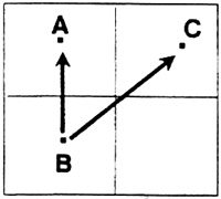
 a. Squares These are very easy to draw onto a map, or if you are making your own map up you can start with squared or graph paper and draw on that That's the good news. All the time units move either horizontally or vertically then the movement rate is uniform. However any diagonal shifts, which are desirable to maintain flexibility of movement direction, gains units an unfair advantage since they are in effect moving a greater distance than up, down or across:
Back to a school maths lesson - the distance from B to C is greater than B to A. I'm sure someone out there can tell me what the ratio between the two lengths is.
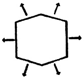
 b. Hexes This type of grid is far more favourable than squares; the effect means uniform movement in the six directions from the starting hex.
It is rightly the basis of most board wargames' map systems. The only drawback is how to impose the grid over a commercial or copied map since the things are darned difficult to draw (as the editor will probably testify to from my original papers to him). I haven't delved very deeply but clear polythene sheets pre-printed with the hex grid may be available from a commercial concern? Certainly pre-printed paper can be bought on which you can draw your own map freehand.
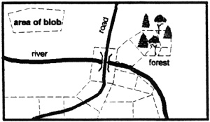
 c. Blobs I personally have recently become enamoured with the blob as a grid system!! This entails taking the map you wish to use and, freehand draw on your own areas e.g.
The blobs can be altered in size and shape according to the terrain so that clear terrain will have larger blobs than woods, soft ground etc. Thereby units will take a longer time to cross a given feature. The ever Present drawback is that the blobs have to be hand drawn onto the map initially but I think they are a very flexible form of map grid. I would advise you to be careful when drawing blobs as to where corners meet so as to avoid ambiguities and possible arguments:
 You can move from A to B or C, but what about A to D or C to B? I tend to say '"Yes" you can considering the distance to be moved each time is about the same.
Whatever sort of grid is used, movement calculation is very much more simple to work out than measuring distances. My infantry regiment mentioned above will now move 15 hexes or blobs a day; if they cross a river other than by a bridge this costs 10 hexes; or if they go up a hill contour they will lose 3 blobs, and so on.
The Marking of Maps
Having found a suitable map and decided on how you will work out movement, the choice now is how to keep track of where all the units are on it:
a. Draw on it Easy, draw the units on the map. Use a pencil instead of a pen and you can rub out the old position and draw in the new one. Obviously this will spoil the map quickly and almost certainly make it unusable again.
b. Cover it Buy some sticky backed clear sheeting, cover the map with it and use either chinagraph (grease) pencils or washable pens to mark positions. If the map is of an A4 size paper (US equivalent, 8 ½ by 11) an alternative to sheeting is a clear plastic document holder now widely available in stationers. A third choice is to laminate the map, again some stationers or photocopying establishments are advertising this is service or you may have an understanding employer.
c. Stick it Mount the map On a sheet of corrugated cardboard or on a soft boarding and then use map pins, perhaps with 'flags' of paper on the pins containing the necessary unit information. This certainly an easy way of moving units about but again the map is spoilt for future use. Consideration of storage space is also needed if the map is to be used over a long time.
That's my offering on the subject, sufficient I hope to jog a few brain cells into action. If anyone has other ideas or suggestions I suspect the Editor would be only to too happy to receive them; I for one would be interested to read other peoples' thoughts.
Back to Table of Contents -- Lone Warrior #112
Back to Lone Warrior List of Issues
Back to MagWeb Magazine List
© Copyright 1995 by Solo Wargamers Association.
This article appears in MagWeb (Magazine Web) on the Internet World Wide Web.
Other military history articles and gaming articles are available at http://www.magweb.com
