The minor road nets across Europe don't appear on the mapsheets and with good reason. They are considered present in every hex; their effects are built into movement costs and ZOC rules. This has always been quite acceptable in the European countryside. In the desert, however, things are different. The coastalhighway is the only road available between the Nile Delta and Tunisia.
In reality, travel in the desert was served by a quite extensive number of desert tracks or trighs. Combat units saw little speed benefit from these tracks; their surface was seldom much better than that of the surroundin g desert. Their great worth was as navigational aids and as such were instrumental in the movement of rear area units and supplies. Simply not getting lost was a high priority while traveling across the desert.
The British reflected the need for ocean-like navigation across the sands in their nickname for the desert. They simply called it "the Blue." According to Peter Elstob they gave it the name "in half-conscious acknowledgement of its resemblance to the sea." The label also provides an appropriate allusion to the desert's wide open dome of sky.
Unlike most North African simulations, "War in the Desert" omits the system of desert tracks. Their effect is probably factored into the cost of traveling through clear terrain, as with the minor roads in mainland Europe. The lack of a pervasive network of secondary roads is reflected by giving a ZOC to brigades, regiments and cadres.
Examining the historical course of the desert war reveals at least several times when the specific location of tracks was important at an Europa scale. For example, at various times'Mechili and Msus (hexes 18:4020 and 18:3624) were substantial British supply dumps (among other inland locations). These places were selected because they were hubs of the important system of desert tracks that crisscross the Libyan desert. In Western Desert, the accumulation of supply steps at either of these locations would be highly unlikely because of their inaccessibility stemming from high non-road SMP costs.
The Italians were able to slip the noose of 7th Armored Division by withdrawing from Mechili along the Slonta track, reaching the coast road in a night and a day. The Trigh Capuzzo and Trigh el Abd were important during the Crusader battles.
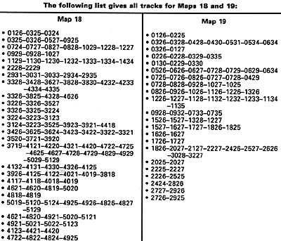
Aside from these historical reasons, the best reason for including tracks in the desert is for feel. The trighs make it just seem more like "The Blue." The following rules and track layout allow players to add a system of tracks to their Western Desert maps.
The track system from the Nile Delta to Tripoli is included. If there is any interest, I will gladly expand the tracks to NW Africa. I would have listed tracks for the Sinai and Palestine, but my best sources on these areas date from the Arab-Israeli wars of 1948 and 1956 and I am unsure of their accuracy for 1941.
Track Rules
Effect on Movement.
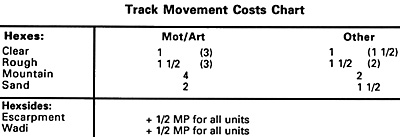
Advantages gained by moving along tracks are listed in the "Track Movement Costs Chart" appearing on the facing page. (Although we don't need the mountain costs yet, if we do tracks in Tunisia, we will.)
Effect on Supply Movement.
Modify Rule 12D as follows: It costs no SMPs to move supplies by rail. It costs one SMP per hex to move a step of supply by road. It costs two times the combat/ motorized MP cost of a hex in SMPs to move a step of supply by track. It costs three times the combat/motorized MP cost of a hex in SMPs to move a step of supply off-road and off-track.
Modifying the Mapsheets.
Draw your tracks in pencil, not pen. The gray of a pencil's lead doesn't, usually overpower the other map features. Also, it's entirely possible that some of the tracks given in this article might be off by a hex or so.
When some desert-crazed reader discovers an error and writes in, the paths of your tracks will be easy to change. I drew my tracks with a series of dashes perpendicular to (not following) the direction of the track (see the figure in the heading above).
Of course, the simplest method is to just use a straight, solid pencil line.
(A heavy dotted line as per the road symbology appearing in Balkan Front worked well for me. -RG)
An important point about Europa topography should also be noted while drawing your tracks. All roads in Europa hexes intersect, and this principal should be applied to tracks as well. The exception is the Matruh to Tobruk rail line. This is a special case, since this line is constructed during the course of the game.
The funny little track running from 18:2228 to 18:2229 really does dead-end. It turns into Main Street, Nofilia, and dies.
Try out this secondary road system in your next game of Western Desert and advise TEM of the results.


Back to Europa Number 15 Table of Contents
Back to Europa List of Issues
Back to MagWeb Master Magazine List
© Copyright 1990 by GR/D
This article appears in MagWeb (Magazine Web) on the Internet World Wide Web. Other military history articles and gaming articles are available at http://www.magweb.com