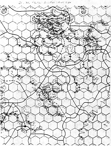
This issue Arthur discusses Finland and the surrounding area as shown on Maps 1B, 2A, 5B and 6A.
Misplotted Cities
Pudasjarvi (currently in 5B:2901 (6A:2933) should be in hex 6A:3032, as it is actually 5 miles southeast of the Livo River (Livojoki). The road through Pudasjarvi should similarly be corrected to show it stays south of the Livo. Kuopio (currently in 5B:4201) should be in 5B:4302. Kuopio is actually on the peninsula in 5B:4302 jutting into Lake Kali (Kalivesi). The road junction shown in 5B:4201 is correct. Kotka (currently in 1B:0307) should be in 1B:0405. This city is 63 miles in a straight line distance from Viipuri and 75 miles from Helsinki. Also, the bay shown in hexes 1B:0404, 0305, 0405 is Kotka bay (Kotkalahti) with the city actually on a small island at the tip of the peninsula shown in 1B:0405.
Finnish Rail Lines
The rail junction shown in 5B:4509 is the same junction as that in 5B:4310. Neither hex location is correct for the junction. Rail lines in this area meet at the small town of Haapamaki in hex 4408 (Haapamaki is 24 miles east of the lake and 51 miles from Tampere). Additionally, the Pori/Haapamaki line crosses the northern portion of the lake at the Virat bridge (hexside 4409/4410). To be historically correct, the section of the Pori-Haapamaki line in hexes 4411, 4410, 4409, and 4408 should be a road until June 1940, as the rail line was still under construction prior to that date.
Several of the rail lines on the South Finnish Plain between Viipuri and Helsinki are incorrect. In particular the main line between Helsinki and Viipuri makes a bend to the north to the town of Lahti (5B:5107 or 1B:0107) on the southern shore of Lake Piijanne not shown on the current maps. The road currently running between 5B:4605 and 5B:5005 is also incorrect as it in fact joined the main rail line at Lahti. The Kotka rail line must also be moved to correspond to the correct location of that city. Finally, the rail junction in hex 1B:0302 actually occurs at Viipuri.
According to the 1939-40 eition of "The Finland Yearbook" published by the Finnish government the section of rail line from Kontiomaki to Taivalkoski (6A:3631 to 3030) was also under construction at the time of the Winter War. (I have been unable to determine exactly when this rail line was completed, however.)
Additional Finnish Rivers
There should be a minor river between hexside 5B:4809/4810. The river currently shown south of Tampere actually went from the large western lake to the small southern lake and then to the large eastern lake. Current depiction of the river accurately shows that moving from either 4809 or 4810 to Tampere would involve crossing the river once, but allows units to move directly from 4809 to 4810 (or vice versa) without any penalty, when in fact they would have to cross the river twice!
There should also be a minor river between 6A:4932/4933. This represents the two mile wide channel at Savonlinna between Lakes Haki (Hakivesi) and Pihiaja (Pihlajavesi).
The Piellisi river (Piellisijoki) should be added to the maps. This would run just to the south and east of the chain of hexes 6A:4530, 4529, and 4429 and would connect Lakes Pielinen and Ori (Orivesi). This river runs through a chain of small lakes and is for the most part between one and three miles wide.
The river shown next to Kotka on the current maps represents the Porvoo. This is a very minor river, however, and probably should be deleted from the maps. In its place I would substitute the Kotka river which would run just to the west of the chain of hexes 1B:0405, 0305, 0205, 0106 (5B:5106), and 5B:5006/4906. The Kotka is the largest river on the south Finnish plain and averages about a half mile in width (in many places it is much wider as it to flows through a chain of small lakes).
The Saimaa canal between the Gulf of Finland and Lake Saimaa should also be added to the maps just west of hexes 1B:0202, 0302, and 0401. (This canal is the route Finland used to transfer gunboats from the Baltic to the Ladoga Inland Waters Flotilla.)
Finnish Lakes
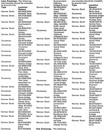
Lake hexsides should be added between 6A:4430/4531, 6A:4532/4632, and 6A:5030/5130 (this last will also appear on northern mapedge of 2A at hex 0130). These represent Lakes Viini (Viinijarvi), Kerma (Kermajarvi), and Simpele (Simpelejarvi), respectively. The causeway which will result in the case of the last lake is correct as the rail line here crosses the center of the lake at a bridge. Lakes Porttipahdan (6A:1730/ 1830/1829) and Lokan (6A:1928/ 1927/ 2027) in the Finnish Arctic are sometimes advanced for inclusion on the maps, but both are man-made reservoirs established after the war.
Hex 5B:4104 as currently shown is ambiguous as it has two distinct pieces of land separated by a lake running through the middle of the hex. Clean this up by shortening the peninsula in the NW portion of the hex so it falls entirely within hex 4004.
Ahvenanmaan Islands
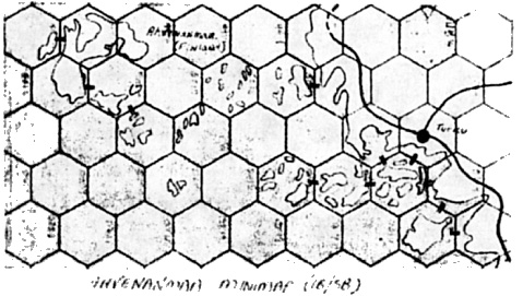
The current depiction of these islands is incorrect as the islands are two hexes too far north. Thus the small island of Eckero should be in hex 5B:4922 and the main island should occupy hexes 5B:4921, 4920, 5021, and 5020. Additionally, the area between the main islands and the Finnish mainland is carpeted with over 100,000 small islands, several of which are larger than Eckero, which is shown.
In several of the hexes in this area, no island is big enough individually to show up, but the aggregate of land area in the hex is quite large. The entire area is considered a hazard to navigation and the main shipping route to Lulea passes between Eckero and the Swedish mainland as a consequence. (It is telling also, that the deep water channel to Turku is marked on Finnish and German charts as a fjord even when far out to sea.)
The entire island group is crisscrossed with bridges, causeways, and ferries. (in fact, the main island of the Ahvenanmaan group shown on the game maps is actually the three islands of Mariehamaa, Lemland, and Lumparland which are joined to each other by bridges.) The attached Ahvenanmaa mini-map shows how I'd redraw the area to reflect all of the above.
Additional Finnish Islands
Add Suur island (Suursaari) at 1B:0605 (clear terrain) and Valamo at 2A:0228 (also clear terrain) to maps. While both islands are small, they are as big as many of the islands shown in the Aegean and both played important roles during WWII. Suursaari in particular had a key role in the war as coastal defense artillery (CDA) emplaced here was a major factor in keeping the Soviet fleet bottled up. Suursaari also saw no less than five regimental size amphibious assaults during the war (the last one being an attack by the Germans on the Finnish garrison as part of Operation Tanne). Valamo is also important for the many CDA batteries emplaced here during the Winter War period.
Map Overlap Problems
Hex 1B:0103 is shown as intermittent lake, while the corresponding hex on map 5B (5103) is shown as clear terrain. Based on the other terrain in the area, Map 1B is probably correct. Hex 2A:0126 is shown as wooded intermittent lake, obviously a problem at the printer; the corresponding hex on map 6A (5126) is shown without the woods. Hexes 5B:1600 and 5B:3000 are shown as rough and clear terrain, respectively, yet the same hexes on map 6A are wooded rough and swamp; the terrain on map 6A should be considered as prevailing.
Hexes 6A:5119 and 5120 are shown as clear terrain, yet those same hexes on map 2A (0119 and 0120) are shown as woods; based on the surrounding terrain map 2A is probably correct. Hexes 2A:0220 and 0327 have part of the land in the hex colored blue; both hexes should be clear terrain.
CENTRAL FINLAND BELOW
Maps


Listing of Lake Crossings and Sea Crossings

Back to Europa Number 13 Table of Contents
Back to Europa List of Issues
Back to MagWeb Master Magazine List
© Copyright 1990 by GR/D
This article appears in MagWeb (Magazine Web) on the Internet World Wide Web. Other military history articles and gaming articles are available at http://www.magweb.com