 Having in the first part of this article described the assault on Madrid of November 1936 (link to Part I in Vol 1 #5), I shall now describe
what can be seen of the battlefield today. Despite its rapid expansion since the 1860s, and the consequent loss of much of the area fought over in 1936, Madrid still has much to otter the battlefield tourist. Essentially the areas of interest are threefold, and I shall look at each in turn.
Having in the first part of this article described the assault on Madrid of November 1936 (link to Part I in Vol 1 #5), I shall now describe
what can be seen of the battlefield today. Despite its rapid expansion since the 1860s, and the consequent loss of much of the area fought over in 1936, Madrid still has much to otter the battlefield tourist. Essentially the areas of interest are threefold, and I shall look at each in turn.
THE CITY CENTRE
Unlike many other cities, the centre of Madrid has changed very little since the 1930s. Despite the heavy bombing and shelling, the Puerta del Sol, the Gran Via, the Calle de Alcala, the Calle Mayor and the Carretera de San Jeronimo all look much as they did in 1936, whilst large districts of the city - not only the wealthy barrio de Salamanca, but also the old barrios bajos south of the Plaza Mayor - are almost untouched. The trams are long gone, but the Metro still exists, and, given the appalling madrileno traffic, is by far the best means of getting about (during the battle it was used as a safe method of moving troops about, as an air-raid shelter, and even, in the case of the section between Goya and Diego de Leon on Line 4, as a munitions factory).
Many of the stations have now been modernized, but one that has retained its original flavour and lies in an area that was particularly heavily bombed is Tirso de Molina on Line 1. As for marks of the bombing and shelling, many public buildings and monuments - for example, the Palacio de Comunicaciones and the Puerta de Toledo are scarred by shrapnel to this day, whilst numerous houses in the Acacias Embajadores district show signs of having been damaged and later repaired. Nearby there are some impressive ruins at the foot of the Calle Meson de Paredes. In the Gran Via, which was so heavily shelled that it became known as '15 Avenue on account of the number of 155mm shells that fell there, there is little sign of the heavy damage that it suffered; however, the Telephone Building - the Telefonica - despite being hit by at least 129 shells and bombs, still stands and it is easy to appreciate how both Republican artillery observers and the international press corps must have had a grandstand view of the fighting from its
PINTOR ROSALES-PARQUE DEL OESTE
MONCLOACIUDAD UNIVERSITARIA
Of all the districts of the city, perhaps none was so heavily affected by the fighting as the one north of the Plaza de Espana between the Paseo del Pintor Rosales and the Calle de la Princesa. Heavily exposed to Nationalist fire, this whole area had to be rebuilt virtually from scratch, and in the process lost much of its orginal character. However, a walk along the Paseo del Pintor Rosales from the Plaza de Espana is well worth the trouble. Immediately on the left after leaving the latter may be found a large mound with steps leading up to it past a monument consisting of a shattered figure lying on a sandbag barricade.
Now occupied by a transplanted Egyptian temple (honest!), this was in 1936 the site of the Montana barracks, whose garrison was massacred during the uprising after it had attempted to join the Nationalist rebellion. From the esplanade beyond the temple a wonderful view may be had of the valley of the Manzanares, the Casa de Campo, and, in the far distance, the Sierra de Guadarrama, this being an excellent vantage point from which to comprehend the fighting. Immediately below is the old North Station, which was used as a major command post.
Along the Paseo del Pintor Rosales to the right, meanwhile, stretched an important trench line, the buildings that face on to the Paseo constituting a further line in that they were all heavily fortified and linked by tunnels and the roads between them barricaded. At the end of the Paseo del Pintor Rosales one comes to the deep ravine of the Parque del Oeste. Here one comes to what became the Republican front line from the conquest of the University City to the very end of the war, this crossing the end of the Paseo del Pintor Rosales at right angles and running up the Paseo de Moret to the Plaza de la Moncloa to the right. With the exception of a bullet-scarred wall halfway up the Paseo de Moret. there is little of interest to see here, but directly across the park, which is exactly as it was in 1936 and was the scene of repeated attacks and counterattacks, a line of three pill boxes marks the furthest limit of the Nationalist advance.
Like almost all the concrete defence works still visible on the battlefield, these date from the period of the later siege rather than the battle of November 1936. Above the doorway of one of them is scratched the tower of the Spanish engineers. From here, it is possible to walk back to Moncloa along a pleasant avenue of mulberry trees. About half way along a monument may be observed about fifty yards to the right amidst a clump of trees overlooking the ravine. Dedicated to a certain Doctor Rubio, this is pitted on both sides with an impressive collection of bullet holes. A little further on to the left, on an island in the centre of the main road, will be found the triumphal arch erected to commemorate the Nationalist entrance into the city in 1939.
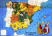 Map of the Spanish Revolution
Larger version - very slow (222K)
The Parque deli Oeste, it will be found is a most peaceful and beautiful spot, but the same, alas, cannot be said for the Plaza de la Moncloa. Aside from the traffic, which is particularly intense here, it is disfigured by its complete reconstruction after the war in a heavy mock- imperial style that was designed to provide a permanent monument to Francos victory. Particularly prominent is the airforce headquarters to the right, this being built on the site of the 'Model Prison' whose fortress-like walls made it a useful bastion. Almost nothing is left to show what the area looked like in 1936, the one exception being an old house on the corner of Isaac Peral and Fernandez de los Rlos.
Plaza del Cristo Rey
A short stroll along Isaac Peral across the Plaza del Cristo Rey- in other words, roughly along the Republican front line brings one to the Hospital Cllnico. A half finished shell in 1936, this was mined and , eventually reduced to rubble, the buildings that one sees today being entirely post-war. They were, however, erected according to the original designs, and it is easy to appreciate their strategic importance. A short walk downhill through the pinewood behind the hospital towards the Museo de las Americas brings one to a shrine to Our Lady.
This marks the site of an old people's home known as the Asilo de Santa Cristina which was held by the Nationalists as part front line, the statue of the virgin being rescued from the ruins by their defenders. Just to the left is a large depression which is, in fact, the remains of the crater left by one of the many mines dug under the Nationalist positions during the siege warfare that continued to rage after the main fighting had died down.
Just beyond the shrine, one comes to the A6 motorway, which has long since supplanted the older highway which ran along the same route in 1936 and is known in most British accounts of the siege as the 'Corunna Road'. Following this to the right past the spired and beflagged pile of the Americas museum (another piece of Franquist grandiosity), one comes after a few hundred yards to a road junction. Standing here one is roughly in the centre of the pocket of territory held by the Nationalists in the Ciudad Universitaria.
Ahead along the main road to the left is the Casa de Velasquez, with the school of architecture beside it to its left; directly across the way is the Faculty of Agronomy, which was another Nationalist strongpoint; and a few hundred yards to the right lies the Faculty of Medicine which was held by the Republicans despite repeated attempts to capture it. All these buildings were rebuilt more-or-less in their original form, but most of the others scattered around on all sides are modern and were not there during the siege - certainly the sense of emptiness that one gleans from pictures of the area in 1936 is completely absent. Nor, at least to my knowledge, can anything now be seen of the trenches and dugouts that honeycombed the whole area.
THE CASA DE CAMPO AND THE SOUTHERN OUTSKIRTS.
By far the most rewarding area of the battlefield to visit is the Casa de Campo. Although the whole area is covered with traces of the fighting, I shall here restrict myself to the area of the immediate front line. For a good circular tour, one should take the 75 bus from the Plaza de Callao in the centre of the city to its terminus beside the river Manzanares. Immediately across the road from the bus stop, there is an area of two-storey detached houses. Built in the 1920s as the Colonia del Manzanares, this district was heavily damaged in the fighting, being, as will become apparent, virtually in the from line, but has been rebuilt more-or-less at was.
Leaving this area behind and walking along the bank of the river, immediately ahead one sees a red-brick railway bridge This is the famous Puente de los Franceses, so called after the French engineers who built it in the 1850s, and 1936 carried what was then the main railway to northern Spain over the Manzanares. Somehow remaining intact throughout the fighting, it was a vital Republican bastion, the machine-guns mounted upon it dominating much of the lower slopes of Garabitas and, even more crucially, the footbridge built by the Nationalists to link their beleaguered salient in the Ciudad Universitaria with the rest of their positions. Beyond it there is a roadbridge, as there was in 1936, but the original was blown up by the Republicans, the bridge to be seen today being post-war.
 At the end of the embankment turn sharp left, and after a few yards a footbridge will be found across the M30 motorway (this has, incidentally, completely changed the character of the area where the Nationalists crossed the river, and renders a visit to that spot utterly unproductive), from which a good impression may be obtained of the Nationalist front line, which ran along the crest ahead. From the other side of the foot bridge, walk across the open area towards the trees beside the railway line, crossing in the process an area of hummocks and scrub. This marks the Republican front line, although there is little to see other than a tiny fragment of a brick pillbox just to the right.
A little way along the railway one comes to an electricity substation, and this marks the Nationalist frontline. Running up the hill from it to the left will be found a line of trenches and, near the top, a most ill sighted V-shaped casemate. From here it is possible to carry on up the ridge whose lower slopes one has just climbed to Garabitas, which is crowned by watch-tower designed to guard against fire. Although in places the going is quite steep the climb is certainly worth it: a marvellous view is available fro the summit, and it is easy to see why the geight was so crucial. All around, meanwhile, are Nationalist trenches, shelters, and artillery positions, including the remains of a dugout faced with concrete.
Walking back the way one has come back towards the city, at about the half-way mark a broad track is crossed leading to the left. After about half a mile this leads to the northern limit of Nationalist penetration of the Casa de Campo during the battle, the front line there being marked by another line of trenches. Somewhat further on in the far northern tip of the park one encounters the Republican positions which they faced, the whole of this area witnessing fierce fighting due to the repeated Republican attempts to recapture Garabitas from the north.
Assuming the visitor does not have time for this lengthy diversion, at the track we have just mentioned drop down to the road that runs a little way to the right and follow it back down towards the river. At the bottom of the hill turn right and climb up the steep slope overlooking the road, and at the crest of the hill one reaches a complex of trenches that in fact extends right back along the spur that can be seen on the right.
Pillboxes
Perhaps the most impressively preserved section of the whole battlefield, the whole area repays careful exploration. Note in particular the two pill boxes on the northeast face of the spur, and the manner in which the vegetation is different from that in the most of the rest of the park, the original pines and holm oaks having been lost in a great conflagration during the battle. Unfortunately, other than the foundations of a small pillbox, little is to be seen of the Republican line in this sector (it actually ran diagonally up the hillside to the left and through the fenced-off area before dropping down again into the valley below). However, if one follows the Nationalist line over the spur, drops down the hill to the grove of elm trees that can be seen below, and crosses the ravine which they line by means of the conduit to be found there, a short walk brings you to an exceptionally well preserved section of the Republican line which here bulged out into the Casa de Campo for some way.
Walk straight on along the path which one was on before, keeping the fence on one's right, and, just before it drops down into a shallow valley, more remains are soon encountered in the shape above the path and to the left. From here the Republican line ran back along the ridge to the left before eventually swinging round to cover the park's two lakes. The whole area is pitted with shell holes, and was clearly the scene of much fighting. However, rather than following this spur, the visitor should now drop down into the valley and climb up the spur on the far side across an open area. Near where the scrub begins again at the top, a faint line of trenches is passed.
Front line
This is the Nationalist frontline, and just near the road beyond will be seen some low ruins. Pitted with bullet holes, these are the only remains of a church and cemetery that once stood at this point, and were an important Nationalist strongpoint that was repeatedly assaulted by the Republicans. Virtually overhead is a cablecar line that runs from the Paseo del Pinto Rosales to a station about a half-mile to the right, and is for the footsore and weary pilgrim an excellent way home.
Just down the slope some way to the right is a concrete pillbox entered from one of the many tunnels the Nationalists dug under these ridges, whilst the scrub directly beneath the cablecar line conceals more trenches. From here the front line dropped down into the re-entrant below, and then climbed up again on to the ridge on the other side. Near its foot another pill-box may be observed, but on the top, whilst traces may be observed of trenches and shell-holes, the remains are too eroded to be of much interest.
From the cable car station the Nationalist line ran for some distance westwards along the ridge on which it stands, and numerous trenches may be observed along its length as well as some advance positions at its foot. Meanwhile, some traces of the Republican positions may be observed in the valley near the Metro line. Near Batan station, both frontlines left the Casa de Campo to disappear amongst Madrid's extremely unattractive southern suburbs. Extremely unattractive though they also were in November 1936, the character of these districts has entirely changed in that they are now a mass of high-rise flats. Here and there amongst the new developments are clusters of the single-storey barracas that typified them during the war, whilst the bull-ring and military hospital of Carabanchel, both of which were fiercely defended at the beginning of the battle, and, indeed, what remains of the old village itself, may still be seen. The area, however, is in general a poor one, and tourists would be advised to take some care.
Returning to our tour of the Casa de Campo, unless the visitor has decided to catch the cable-car home, he should drop straight down into the valley to the south, and at the bottom turn to the left along the path that runs at the foot of the ridge. If this is followed in the direction of the city centre to the east, a car park is soon observed on the right.
Lake
In 1936, this was a lake, the Republican line running just to the west of it, although the only trace of it is the foundations of a pill-box located right on the path itself. As witness the many shell holes, here raged some of the fiercest fighting to take place in the Casa de Campo, with the Republicans beating off attack after attack on their positions, and for their part repeatedly trying to capture the ridges above.
From this point, it is possible to return to the city centre by metro from Lago station on Line 10. Thus ends our tour of the battlefield of Madrid, though visitors provided with cars might also care to visit the Cerro de los Angeles, and the battlefields of Boadilla, the Jarama, Guadalajara and Brunete, all of which figured in the long campaign focused on the city in the period after the initial assault. Also a must is the army museum: though disappointing in some ways, it does have an excellent relief model of the trench lines round the Ciudad Universitaria. On a practical note, in summer Madrid can be extremely hot, and anyone who wishes to walk the Casa de Campo, in particular, should wear suitable headgear and carry plenty of water; even more importantly, for obvious reasons, on no account touch any metallic object that is in any way suspicious, or make any attempt to use metal detectors.
FURTHER READING
The battle of Madrid produced many eye-witness accounts of which some of the more interesting are:
J. Sommerfield, Volunteer in Spain, (London, 1937)
E. Romilly, Boadilla , (London, 1937)
G. Sanford-Cox, The Defence of Madrid, (London, 1937)
K. Scott Watson, Correspondent in Spain , (London, 1937)
H.E. Knoblaugh, Correspondent in Spain, (London, 1937)
and, from the Nationlist viewpoint,
H. Cardozo, The March of a Nation, (London, 1977).
For a more historical account, see
G. Hills, The Struggle for Madrid,
(London, 1977)
Though it is disappointing on Madrid itself,
S. Monterko Barrado, Paisajes de guerra: nueve itnerarios por los frentes de Madrid
(Madrid, 1987), is an excellent guide to Civil War sites in the region as a whole.
Back to Battlefields Vol. 1 Issue 6 Table of Contents
Back to Battlefields List of Issues
Back to Master Magazine List
© Copyright 1997 by Partizan Press.
This article appears in MagWeb (Magazine Web) on the Internet World Wide Web.
Other military history articles and gaming articles are available at http://www.magweb.com