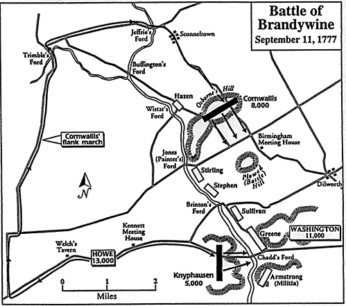
Map Two: depicting General Howe's strategy of pinning tbe American army with Knyphausen's column, while marching the bulk of his army, under Cornwallis, around the American right flank. The map also indicates the important fords across Brandywine Creek and the area where the main battle occured on Plowed Hill. The divisions of Stirling, Stephens and Sullivan redeployed on Plowed Hill to meet tbe threat posed by Cornwallis. When these divisions were thrown back, Greene pulled his division from Chadds Ford (leaving Wayne's division to fend off Knyphausen) and covered the army's retreat with a rearguard action near Dilworth.

Back to Battle of Brandywine Accounts (Part II)
Back to American Revolution Journal Vol. I No. 1 Table of Contents
Back to American Revolution Journal List of Issues
Back to Master Magazine List
© Copyright 1997 by James E. Purky
This article appears in MagWeb (Magazine Web) on the Internet World Wide Web.
Other military history articles and gaming articles are available at http://www.magweb.com